
MORE STORMY WEATHER AND HIGH HEAT ON HORIZON
By Miriam Raftery
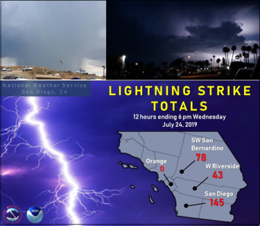
Photos: National Weather Service storm images in Campo and El Cajon, plus lightning totals.
July 25, 2019 (San Diego’s East County) - San Diego County had 145 lightning strikes during a 24-hour period ending at 6 p.m. last night. Thunderstorms doused East County’s mountain and rural areas, producing some dramatic downpours and striking images.
Even the usually parched desert community of Borrego Springs logged .21 inches in just 10 minutes. Borrego resident Bob Kutscher described the deluge as “BIG loud windblown drops that I thought was hail but ended up being very loud rainfall.”
FORECAST FOR THIS WEEKEND AND NEXT WEEK:
Isolated thunderstorms are forecast to continue in the mountains and deserts Friday. This weekend, increasing heat will raises temperatures into the 110s in San Diego’s desert areas Saturday and Sunday.
Monsoon moisture is forecast to return early next week and continue through mid-week, so keep your umbrellas handy.
If you hear thunder or see lightning, go indoors or into a vehicle and stay there for at least 30 minutes after the thunder stops, since lightning can strike 10 miles or more away, even if there are blue skies overhead. Stay out of swimming pools or other water sources whenever thunder roars.