
 By Miriam Raftery
May 23, 2020 (San Diego’s East County) – Memorial Day is going to be toasty, ushering in a heat wave through Friday with temperatures 15 degrees above normal, predicts National Weather Service meteorologist Bruno Rodriguez.
An excessive heat watch has been issued from Monday morning through Friday evening for San Diego County’s desert areas.
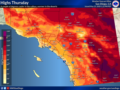
Midweek, temperatures in San Diego County’s deserts may break daily records, the National Weather Service predicts, with extreme temperatures up to 112 degrees Fahrenheit in lower desert areas and up to 105 degrees in high desert areas Wednesday and Thursday. Tuesday and Wednesday look hottest for inland valleys, where highs will range between 90-102 degrees.
These will likely be the hottest of the year so far for desert areas, where heat risk will be especially high. The heat will begin to relax its grip on Friday, especially across inland valleys, but will linger in the deserts before temperatures descend further next weekend.
Along the coast, temperatures in the high 70s to low 80s are expected.


Recent comments