Major fault line runs under proposed Ocotillo wind site slated to provide energy for San Diego, ECM investigation finds
By Miriam Raftery
Jim Pelley and Parke Ewing contributed to this report
April 11, 2012 (Ocotillo) – Public document searches reveal that “injury or death” from strong seismic ground shaking and ground failure are potential significant impacts of the Ocotillo Express wind facility approved last week by Imperial Valley planners, an ECM investigation has found.
Those troubling admissions appear in a preliminary report on seismic issues in the Bureau of Land Management's (BLM) Environmental Impact Report (EIR).
In recent days, nearly a dozen mild to moderate earthquakes have rattled the Ocotillo area. The region continues to be rocked by aftershocks from the Easter 2010 quake just south of the border, which measured 7.2 on the Richter scale.
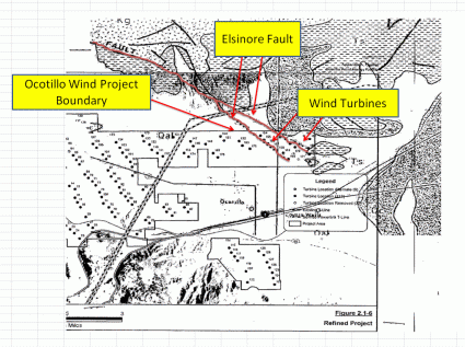
Now, an overlay of project maps with the most U.S. Geological Survey maps reveals that the Elsinore earthquake fault—capable of generating up to a 7.5 quake, runs directly beneath the Ocotillo Express project site slated to house turbines approximately 450 feet or more in height on ground that some earthquake experts say could liquefy.
Each of the project’s proposed 112 wind turbines would contain blades approximately 165 feet long, according to Pattern project documents: http://www.ocotillowind.com/project_documents/2011-Sept-OcotilloPresentation.pdf.
John Dunlop at the American Wind Industry Association indicates blades that size would weigh approximately 15 tons, on average.
Setbacks from public roads proposed for the Ocotillo project are just 1.1 times the height of the turbine, or around 455 feet for a 450 foot hall turbine—each with whirling blades 165 feet long, or about the length of the wingspan on a Boeing 767 jetliner. 

John Calaway, director of wind development at Pattern Energy, the project applicant, refused to discuss seismic concerns. “We’re not going to be making any comments to your magazine,” he said.
ECM has repeatedly contacted Pattern seeking to include its side of the story and the company’s representatives have repeatedly failed to return numerous calls and e-mails requesting interviews to address serious issues with the project.
Asked point blank if he can offer assurances that the project can be engineered to withstand liquefaction in a major earthquake, Calaway repeated, “We’re not going to comment,” then slammed down the phone.
ECM news partner ABC 10 News has also sought comment from Calaway and as of press deadline has not received a response, either.
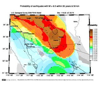
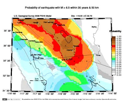
The risk of a major quake occuring in the vicinity is high, per the USGS. The USGS has a search tool to calculate quake risk. Using the exact longitude and latitude of Ocotillo, the odds are a whopping 60% that a 6.5 quake or higher will occur within 30 years (the expected life of the wind project) within 50 km (31 miles) of Ocotillo. https://geohazards.usgs.gov/eqprob/2009/output/5302_large.png https://geohazards.usgs.gov/eqprob/2009/index.php
The Elsinore Fault rund directly through the project site, multiple sources confirm. An overlay of the project site map and quake data indicates that some 15 turbines are on or very near the fault itself:
Experts disagree on the likelihood of a major quake. According to the USGS, The Elsinore fault is capable of a 7.5 quake , the North County Times has reported.
“The southernmost part of the Elsinore fault enters the project boundaries, but whether individual turbines or foundations would sit on the fault cannot be determined with a map of this scale,” Thomas Rockwell, professor of geological science at San Diego State University told ECM, though acknowledging that the turbine sites appear “very close” to the fault. But he added, “The key is whether they actually place them directly across the fault and whether they are designed to withstand fault rupture.”
Historically, the Elsinore fault has produced a 7.0 or higher quake every 1,000 years or so, with the last one within the past 300 years, Rockwell said. He added that should a major quake occur, displacement would likely be less than three feet.
ECM contacted Stephen Mahir, director of the Pacific Earthquake Engineering and Research Center (PEER) operated by the University of California, Berkeley, regarding earthquake risks in Ocotillo. The project site is sand atop an aquifer. Thus Mahir observed, “It’s the liquefaction that would also be an issue here…If there’s a high water table, soil can basically turn into a fluid during an earthquake and then lose strength.”
Prominent San Diego ecological designer Jim Bell also voiced concerns about the terrain turning to “mush” during an earthquake due to liquefaction. But he added, “throwing blades is a bigger danger.”
There are other faults on or adjacent to the site as well, including the Laguna and Yuha Wells faults.
Why, does the project’s final EIR claim merely that “the project site is located within three miles of the Elsinore-Coyote Mountain Fault surface trace” and further, that typical earthquake probabilities are based on a 10 percent chance that this size of an earthquake would occur in 50 years? Moreover the EIR claims the risk to the public is “relatively small” though acknowledges that severe ground shaking could injure construction workers due to damage to turbines or transmission lines.
An appeal filed yesterday by the California Environmental Law Project seeks to have the Imperial Valley Supervisors overturn an approval by the county’s planning group. Among other issues, the appeal raised serious questions over seismic safety.
“All the assurances about the location of the project in relation to the Elsinore fault are substantially inaccurate and potential impacts discussions need to be altered accordingly,” said the group’s lawyer, Lisa Belenky. See FEIS Figure 2.1-6. The FEIR at §4.11-40 states that the `applicant shall not locate project facilities on or immediately adjacent to a fault trace.’ As shown in Exhibits A and B, many of the project wind turbines are located near or on faults.”
The Ocotillo area has experienced an increasing number of mild to moderate quakes in recent days. On April 8, KGTV reported 11 quakes in a single night: http://www.10news.com/news/30856060/detail.html The town was severely shaken by the Easter 2010 Mexico quake south of the border including a 5.7 aftershock centered just 5 miles from Ocotillo: http://www.myvalleynews.com/story/48636/ .
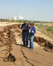
“Those of us who were down in Ocotillo during the local 5.7 quake and/or the 7.2 from Mexico know that the shake factor is very violent in Ocotillo due to the ground consistenting of mostly sand,” said Jim Pelley, an engineer who lives in Ocotillo. “From an engineering standpoint, to have a structure that is over 100 tons, most of the weight being at the top, 468 feet tall attached to a foundation that is only 8 feet deep by 70 foot diameter in sand, it is very conceivable that with an earthquake of 6 or better it will topple over.”
Ocotillo resident Edie Harmon recalls, “It took me more than four hours to get from the door of my house to the refrigerator which had opened and deposited contents on floor...a struggle in the dark because so many boxes of books and papers had come flying down…When it hit, I was at the Border Patrol checkpoint at Jacumba and thought the agents were trying to roll the van. Lots of big rocks/boulders on the interstate from there to Ocotillo, but no cell phone reception to request that highway be closed.
I was fortunate NOT to be at home when the quake hit, because I doubt that I would have survived being pelted with flying boxes of books! “ She added, “I slept in the car for at least a week; there were so many strong aftershocks nearby. But then I was just a mile from the epicenter…. I wonder if 450 ft tall wind turbines with ton of weight high in the air could have withstood something like that without some very serious damage. I wouldn't want to have to watch them swaying in the air.”

Jim Pelley also recalls the 5.7 quake and provided photos of damage in his Ocotillo home. “It was about 9:30 at night. The lights went out as soon as what sounded like a bomb hit. I grabbed my 5-year old grandson, threw him on the bed and covered him; it was pretty violent, the scariest thing I ever was faced with…It went on for about 3 minutes, it seemed like forever…”
In the final EIR, some mitigation measures are called for such as adding additional concrete and increasing size of foundations—items that environmentalists claim should trigger a new environmental review for impacts on habitat and more.
Further, the document states that “structural damage to wind turbine generators, overhead transmission lines, or other project facilities could injure construction workers at the project site. Although impacts would not be completely avoided, Mitigation Measure PHS-3, which requires the Applicant to conduct a full geotechnical study to evaluate soil conditions and geologic hazards on the project site and submit it for approval to the BLM for federal lands and the Imperial County Planning and Development Services for County lands. The Applicant shall determine the final siting of project facilities based on the results of the geotechnical study and implement recommended measures to minimize geologic hazards. BLM and Imperial County Planning and Development Services would evaluate any final facility siting design developed prior to the issuance of any building or grading permits to verify that geological constraints have been avoided.”
ECM researchers found only two significant links regarding seismic testing on wind turbines. In February 2010, the San Diego Union-Tribune reported that a shake table test on an 82-foot tall turbine was slated to take place at the University of California, San Diego. http://www.utsandiego.com/news/2010/feb/07/wind-turbine-getting-seismic-shakedown/ . Shortly after that test, ECM repeatedly contacted the lead researcher to request results back in 2010. We requested results again recently for a story published last week. We have never received a response. Some results were later published here: http://cwec.ucdavis.edu/forum2010/proceedings2/Elgamal_CWEC2010.pdf
However it’s unclear whether turbines made by Pattern were ever tested, or whether turbines the same height have ever been tested, or whether turbines tested passed tests simulating earthquakes as strong those that are possible in the Ocotillo area.
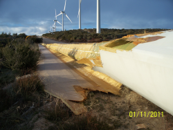 SDG&E’s application for the Ocotillo wind project to the California Public Utilities Commision listed among Pattern’s “success” stories the Kumeyaay Wind project at Campo in San Diego's East County.
However virtually all 75 blades at the Campo facility had to be replaced and the site was offline for three months after huge chunks of blades were hurled off during a winter storm. A witness reported an electrical flash before the facility went dark, as ECM previously reported. Rusted turbine parts remain littering the fields at Campo, more than two years later. Litigation is ongoing.
Pattern has told Imperial Valley planners that it has since changed blade suppliers, however the incident remains a troubling reminder that forces of nature can lead to catastrophic results at some wind facilities.
Just how troubling will Imperial Valley Supervisors find Pattern’s refusal to respond to inquiries from the public and press regarding serious seismic and public safety concerns?
That remains to be seen. Supervisors have announced a hearing April 24 to consider multiple appeals seeking to overturn the Planning Group’s approval of the Ocotillo Express wind project.


Comments
The truth is voluntary
This is exactly what you get with this greed driven renegade industry. There are no regulations. Everything is voluntary, including the truth. For that, you have to beat it out of them with legal action.