By Miriam Raftery
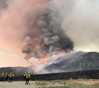
Photo: El Dorado Fire, courtesy of San Bernardino National Forest via Twitter
September 6, 2020 (San Diego) – Major new wildfires ignited yesterday, forcing evacuations in San Diego and neighboring San Bernadino counties as well as Fresno County. even as firefighters continue battling lightning complex fires elsewhere in the state. As of this morning, there are over 14,800 firefighters battling 23 major fires and lightning complexes in California. View map of major wildfires statewide: https://www.fire.ca.gov/incidents/
The new fires yesterday include the Valley Fire in San Diego County's Japatul, Carveacre and Lawson Valley areas that destroyed 10 homes overnight, as well as the El Dorado Fire east of San Bernadino, which has torched 2,727 acres in the Yucaipa area and is 5% contained. The San Bernardino National Forest feed on Twitter reports 300 foot high flames.
Since the lightning siege that started on Saturday, August 15, 2020, there have been nearly 14,000 lightning strikes. During this time-period, there have been more than 900 new wildfires, which have now burned over 1.6 million acres. There have been 8 fatalities and nearly 3,300 structures destroyed.
Cal Fire increased staffing in preparation for critical fire weather in multiple areas of the State, which aided in the initial attack on recent wildfires, with a potential for more wildfires due to critical fire weather conditions.
The National Weather Service has issued multiple Fire Weather Watches and Red Flag Warnings for this weekend and into next week due to potential critical fire weather including strong gusty wind and low humidity. A Red Flag Warning is in effect across much of the Inland Empire down through San Diego.
With Red Flag conditions in many parts of the state over the next few days, fires in these areas can spread rapidly. Making quick and safe evacuation is critical to protecting your life and your family. To learn ways to be prepared, visit www.ReadyForWildfire.org.
Fires of Interest:
**CAL FIRE Incidents**
LNU Lightning Complex, multiple North Bay counties (more info…)
Napa, Lake, Sonoma, Colusa, Solano, and Yolo Counties
*375,209 acres, 89% contained
*Hennessey (merged fires) 317,909 acres, 89% contained
*Wallbridge 54,940 acres, 95% contained
*1,491 structures destroyed
*Evacuations in place
*CAL FIRE Incident Management Team 2 in command
SCU Lightning Complex, multiple Easy Bay counties (more info…)
Contra Costa, Alameda, Santa Clara San Joaquin, Merced, and Stanislaus Counties
*396,624 acres, 88% contained
*20 fires in the complex, several have merged together
*Canyon/Reservoir (merged) 390,649 acres 88% contained
*Deer 3,104 acres 100% contained
*Evacuations and road closures in place
*182 structures destroyed
*CAL FIRE Incident Management Team 6 command
CZU August Lightning Complex, San Mateo and Santa Cruz Counties (more info…)
*86,509 acres, 68% contained
*Multiple fires
*Evacuations and road closures in place
*1,490 structures destroyed
*CAL FIRE Incident Management Team 3 command
Butte/Tehama/Glenn (BTU/TGU) Lightning Complex, multiple Counties (more info…)
Butte, Tehama and Glenn Counties
*66,109 acres, 50% contained
*Elkhorn 46,500 acres, 50% contained
*Ivory/Doe 16,100 acres, 90% contained
*Potters (5-4) 927 acres, 98% contained
*Includes multiple other smaller fires
*16 structures destroyed
*CAL FIRE Incident Management Team 4 in command
**Unified Command Incidents**
Creek Fire, Fresno County (more info…)
Northeast of Shaver Lake (Sierra National Forest)
*45,531 acres, 0% contained
*Evacuations in effect
*CAL FIRE and US Forest Service in unified command
*CAL FIRE Incident Management Team 1 enroute
Valley Fire, San Diego County (more info…)
Near Alpine (Cleveland National Forest)
*4,000 acres, 0% contained
*Evacuations in effect
*CAL FIRE and US Forest Service in unified command
El Dorado Fire, Fresno County (more info…)
West of Oak Glen (San Bernardino National Forest)
*3,010 acres, 5% contained
*Evacuations in place
*California Interagency Incident Management Team 11 in unified command with CAL FIRE and Yucaipa Fire Department
Sheep Fire, Lassen County (more info…)
4 miles southwest of Susanville (Plumas & Lassen National Forest)
*29,570 acres, 86% contained
*26 structures destroyed
*CAL FIRE Lassen-Modoc Unit and CA IMT 1 in unified command
**Federal Incidents**
Lake Fire, Los Angeles County (more info…)
Southwest of Lake Hughes
Angeles National Forest / Los Angeles County Fire Department
* 31,089 acres, 96% contained
August Complex, Tehama County (more info…)
Elk Creek and Stonyford area (Mendocino National Forest)
*325,172 acres 24% contained
*Includes multiple fires including the Doe Fire
Dolan Fire, Monterey County (more info…)
Hwy 1, 10 miles south of Big Sur (Los Padres National Forest)
*34,175 acres, 40% contained
Apple Fire, Riverside County (more info…)
Oak Glen / Cherry Valley (San Bernardino National Forest)
*33,424 acres, 95% contained
North Complex, Plumas County (more info…)
Southwest of Susanville (Plumas National Forest)
*38,164 acres, 40% contained
*Evacuations in place
*Includes the Bear and Claremont Fire
*CA IMT Team 1 is in command
Red Salmon Complex – Humboldt County (more info…)
14 miles northeast of Willow Creek (Shasta-Trinity National Forest)
*37,638 acres, 19% contained
SQF Complex, Tulare County (more info…)
25 miles north of Kernville (Sequoia National Forest)
*55,961 acres, 7% contained
*Castle and Shotgun Fires merged into this complex
W-5 Cold Springs, Lassen County (more info…)
11 miles east of Madeline (Bureau of Land Management - Northern CA District)
*84,817 acres, 96% containment
Dome, San Bernardino County (more info…)
Near Cima (Mojave National Preserve)
*43,273 acres, 98% contained
Blue Jay/Wolf Fire, Mariposa County (more info…)
Yosemite National Park Wilderness
*Blue Jay Fire - 508 acres, 15% contained
*Wolf Fire - 494 acres, 0% contained
Woodward Fire, Marin County (more info…)
3 miles southwest of Olema (Point Reyes National Seashore)
*4,813 acres, 93% contained
Slink Fire, Mono County (more info…)
2 miles west of Coleville (Humboldt-Toiyabe National Forest)
*20,795 acres, 21% contained
Hobo, Vegetation Fire, Trinity County (more info…)
North of Helena (Shasta Trinity National Forest)
*412 acres, 45% contained
Moraine, Tulare County (more info…)
Sequoia and Kings Canyon National Parks Wilderness
338 acres, 50% contained
Rattlesnake, Tulare County (more info…)
Sequoia and Kings Canyon National Parks Wilderness
230 acres, 0% contained


Recent comments