
Update 6:23 p.m. 9/7: The fire is now 17,345 acres and 3% contained.
Update 9:20 p.m.: The fire is now 9,850 acres and 1% contained, 11 structures destroyed. Please see updated evacuation map from County of San Diego at sdcountyemergency.com and never hesitate to evacuate if you do not feel safe.
Update 6:55 p.m. Valley Fire Road Closures are in effect, per CHP tonight:
- Japatul Road at Lyons Valley Rd/Japatual Valley Road
- Japatul Road at Tavern Road/Dehesa Road
- Lyons Valley Road at Honey Springs Road
- Wisecarver Lane at Wisecarver Truck Trail
- Skyline Truck Trail and Lawson Valley
Update 4:22 p.m. The San Diego County Sheriff's Department has issued an evacuation warning for the areas of SR94/Marron Valley Rd and Lyons Valley Rd areas out to Morena Reservoir. Please see the Emergency Map for updated areas that are impacted. 
Update 3:35 p.m. New evacuation advisories include Potrero, Tecate, Barrett Junction and Dulzura. View map here: https://www.sdcountyemergency.com/content/oesemergency/en-us/maps.html.
Per Cal Fire just now: The fire is now 5,350 acres and is 1% contained, burning at a critical/dangerous rate of spread. Structures are being threatened in Carveacre, Lawson Valley, Wood Valley, Lyons Valley, Deer Horn Valley and Sycuan Indian Reservation. sdcountyemergency.com
Per Pulsepoint: #ValleyFire is making a run for Barrett Lake, Lake Morena, and Hauser Canyon.
New road closures: Lawson Valley Rd closed at Skyline TT and Rudnick Dr. Japatul Rd closed from Dehesa to Lyons Valley Rd Lyons Valley Rd closed from Japatul Rd to Honey Springs Rd
Update 2 p.m.: The Valley Fire temporary evacuation point for large animals is the County Animal Services South Shelter located at 5821 Sweetwater Road in Bonita. Call (619) 236-2341. The evacuation center at Joan MacQueen Middle Schoolm 2001 Tavern Rd., Alpine has reopened.
By Miriam Raftery
Photo, right by Kathy Matranga
September 6, 2020 (San Diego’s East County) – The #ValleyFire has scorched 4,000 acres, according to Cal Fire’s incident report this morning. Cal Fire San Diego’s Twitter feed reports that 10 structures were destroyed overnight; the blaze is still zero percent contained.
View a map of the fire via NASA satellite imagery.
Road closures: The San Diego County Sheriff advises that the following road closures are in effect:
- Japatul Rd. and Carveacre Rd.
- Lawson Valley Rd. and Skyline Truck Trail
- Japatul Rd. and Sequan Truck Trail
- Japatul Rd. and Hidden Glen Rd.
According to the US Forest Service, 335 firefighters are battling the flames on the ground. Structures are being threatened in the Carveacre and Lawson Valley, Wood Valley, Lyons Valley, Deer Horn Valley and Sycuan Indian Reservation.
Many have been left without power in the area due to the fire; rolling blackouts are also possible today due to soaring temperatures. Firefighters have been battling the flames in record heat up to 114 degrees in portions of the Valley Fire area, fueled by gusty winds amid a Red Flag warning.

Photo,left by Helen Horvath
Evacuations and shelters
The communities of Carveacre and Lawson Valley have been under evacuation orders.
Those under evacuation orders can go to Steele Canyon High School at 12440 Campo Road, Spring Valley which is accepting evacuees with pets. A second shelter at Joan MacQueen Middle School, 2001 Tavern Rd., Alpine has reopened after briefly closing. All shelters are required to have health and safety measures in place due to COVID-19 including masks and social distancing.
The County has opened additional cool zones over the holiday weekend.
Help with large animals
The Valley Fire temporary evacuation point for large animals is the County Animal Services South Shelter located at 5821 Sweetwater Road in Bonita. Call (619) 236-2341.
The San Diego Humane Society tweeted that they assisting with animal evacuations. If you need help to evacuate animals contact 619-299-7012 and press 1. When evacuating be sure to bring food and water along with your pets. Details @sdhumane on Twitter or follow #SDHSEmergencyResponseTeam.
On the East County Large Animal Evacuation Assistance Facebook Page, neighbors have been offering space to those seeking shelter for animals and help to evacuate animals. The Children’s Nature Preserve on Japatul Road was reportedly seeking help to evacuate 150 animals ranging from camels to zebras.
The shelter at Steele Canyon High School is accepting pets and large animals, the Sheriff tweeted today.
 The Fire began yesterday on Spirit Trail in the Japatul Valley area near Alpine and is under joint command of Cal Fire and Cleveland National Forest.
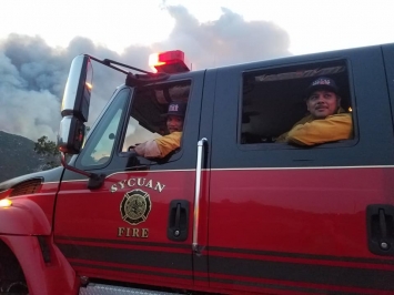
Photo, left: Sycuan firefighters
Harrowing conditions
The fire caused harrowing conditions for some backcountry residents left with no power or water amid a wildfire and pandemic.
Linda Ascione Niman, a musician, evacuated with a car full of guitars. She posted on Facebook, “The fire doubled back. Woke us up in the middle of the night. Mandatory evacuation. We had no electricity so no water. Lots of smoke. Just miserable.”
County evacuation map criticized
" We need info ASAP when fires are raging. Not days later. We have to make decisions about when and how and where to evacuate, especially with COVID in the equation. Fires are dynamic, and your response depends on your best assessment of conditions in the moment," Kim Hamilton, editor of the Deerhorn Valley Antler states in an email sent to ECM this morning.
The Deerhorn Valley Antler has been posting fire updates for the Deerhorn Valley community at https://www.facebook.com/DeerhornValley.
Hamilton criticized the County's mandatory evacuation map provided by the Sheriff yesterday and not updated as of late morning today as "Useless. Dangerous...The map is illegible, unreadable, and covers up mapping information so you ahe no idea whether you need to shelter in place, evacuate immediately, or prepare to evacuate."
East County Magazine gratefully acknowledges the Facebook Journalism Project for its COVID-19 Relief Fund grant to support our local news reporting including impacts on vulnerable communities during the COVID-19 pandemic and coverage of emergencies including wildfires. Learn more: #FacebookJournalismProject and https://www.facebook.com/fbjournalismproject/.
You can donate to support our local journalism efforts during the pandemic at https://www.EastCountyMedia.org/donate.


Comments
East County Alert - Valley Fire Map