

Photos by Lisa Elkins-Goodman, Brett Stalbaum and Joseph Moulton
By Miriam Raftery and Nadin Abbott
Update May 28, 2013 -- The General Fire is now 950 acres and 85% contained, Cal Fire confirms. The cause of the fire has been traced to shooting. One injury has been reported from the fire.
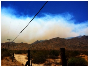
May 26, 2013 (San Diego’s East County) Upodated May 27 9 a.m.– The brush that began yesterday in Rodriguez Canyon south of Highway 78, across from the Banner Grade Store in the 3600 block of Highway 78, is now 850 acres and 20 percent contained. IPN indicates the fire is spreading rapidly and has potential for 300 acres. Helicopter indicates no structures are threatened at this time, however there is a power outage.
Power restoration is expected at 3 p.m. There is no estimate on containment.
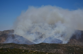
Multiple strike teams have been dispatched to battle the fire on U.S. Bureau of Land Management property.


Comments
Evening update
GENERAL FIRE
General Fire Incident Information:
Last Updated: May 29, 2013 6:45 pm
Date/Time Started: May 26, 2013 12:04 pm
Administrative Unit: CAL FIRE San Diego Unit
County: San Diego County
Location: Banner Grade area, south of Hwy 78 & east of Hwy 79, southeast of Julian
Acres Burned - Containment: 1,191 acres - 90% contained
Estimated Containment 1,191 acres - 90% contained
Structures Threatened: No structures threatened
Injuries: 5
Cause: Recreational Shooting
Total Fire Personnel: 758
Total Fire Engines: 15
Total Fire crews: 32
Total Helicopters: 2
Total Dozers: 1
Total Water Tenders: 12
Conditions: The fire is burning East towards the desert and away from homes.
Morning update
GENERAL FIRE
General Fire Incident Information:
Last Updated: May 29, 2013 6:00 am
Date/Time Started: May 26, 2013 12:04 pm
Administrative Unit: CAL FIRE San Diego Unit
County: San Diego County
Location: Banner Grade area, south of Hwy 78 & east of Hwy 79, southeast of Julian
Acres Burned - Containment: 1,020 acres - 85% contained
Estimated Containment 1,020 acres - 85% contained
Structures Threatened: No structures threatened
Injuries: 4
Cause: Recreational Shooting
Total Fire Personnel: 750
Total Fire Engines: 15
Total Fire crews: 32
Total Helicopters: 3
Total Dozers: 1
Total Water Tenders: 11
Conditions: The fire is burning East towards the desert and away from homes.
Tonight's update
The general fire is 980 acres with 85% containment and 1 injury, they expect containment by tomorrow
Cause of fire
Cal-Fire has determined the cause of the fire, as recreteanional shooters.
Morning update
GENERAL FIRE
General Fire Incident Information:
Last Updated: May 28, 2013 6:30 am
Date/Time Started: May 26, 2013 12:04 pm
Administrative Unit: CAL FIRE San Diego Unit
County: San Diego County
Location: Banner Grade area, south of Hwy 78 & east of Hwy 79, southeast of Julian
Acres Burned - Containment: 980 acres
Estimated Containment 980 acres - 70% contained
Full containment expected tomorrow.
Structures Threatened: No structures threatened
Injuries: 1
Cause: Under Investigation
Total Fire Personnel: 1,217
Total Fire Engines: 52
Total Fire crews: 54
Total Airtankers: 5
Total Helicopters: 8
Total Dozers: 4
Total Water Tenders: 24
Conditions: The fire is burning East towards the desert and away from homes.
Update via Cal Fire
GENERAL FIRE
General Fire Incident Information:
Last Updated: May 27, 2013 6:30 pm
Date/Time Started: May 26, 2013 12:04 pm
Administrative Unit: CAL FIRE San Diego Unit
County: San Diego County
Location: Banner Grade area, south of Hwy 78 & east of Hwy 79, southeast of Julian
Acres Burned: 900 acres
Containment 900 acres - 42% contained
Threatened: No structures threatened
Injuries: 0
Total Fire Personnel: 1217
Engines: 52
Fire crews: 54
Airtankers: 5
Helicopters: 8
Dozers: 4
Water tenders: 24
Conditions: The fire is burning East towards the desert and away from homes.
Power is out as well
Outage Information
Portions of Communities Affected: Borrego Springs/ Shelter Valley/ Canebrake,Julian/ Kentwood In The Pines/ Banner
Start Time: May 27 03:15 AM
Estimated Restoration: May 27 3:00 PM
Circuit: 0221
Customers Out: 120
Cause: We have determined that a fire has caused a problem in the electric system.
How did you get that
How did you get that information? I can't get ANYTHING on SDG&E's website, just an OUTDATED map of outages from over a week ago showing the San Felipe fire....
The outage map
At their website
Memorial Day morning update
@CALFIRESANDIEGO: The General fire is 850 acres and 20% contained no injuries or structure damage. #Generalfire
General Fire over 2300 acres and flared up at 3 am
And Cal Fire notified SDG&E to turn off elec at 3 am, will be off until around 11 according to SDG&E...We could see smoke flare ups from south of there, but seems to be calmed down now, windy tho, so who knows.
Update via Cal Fire
@ViejasAlerts: @CAL_FIRE: #GeneralFire [update] in the Banner Grade area, southeast of Julian (San Diego County) is now 750 acres.
Also there is no structure threat.
Banner Fire
We came down Banner from church about 12:30 evidently fire trucks had all gone past Banner Store and almost to S-2 and then turned around and came back. Bombers were attacking it by the time we got to Shelter Valley. We were in Shelter Valley for a while and the smoke looked like it was getting thicker on S-2 south of us, so we decided to head home in case they might close the road at Oriflame Canyon south of Box Canyon....But there was NO smoke crossing the road once we entered Blair Valley. We could see the smoke back in Rodriques Canyon and Oriflame, and when we got south of Box Canyon we could see it had burned down towards Mason Valley, but it doesn't look like it will come anywhere near Butterfield at this point. Smoke can be seen from our valley behnd the Vallecitos Mtns between us and Blair Valley all the way towards the Southeast. We live in the Vallecitos Valley, south of Mason Valley.
From fire coms it's burning towards the Vallecitos complex
Where it burned last year.
:-)
Thanks for the update, we really appreciate eyewitness reports.
Photos are also helpful!