
East County News Service
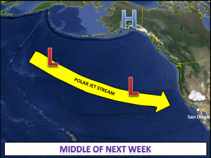
November 10, 2014 (San Diego’s East County) – The National Weather Service predicts that the Polar Jet Stream will be forced south across the Pacific next week as a high pressure ridge moves to higher latitudes. This will force storms to track south, increasing the likelihood of significant rainfall by the middle of next week across southern California.
This could lead to significant runoff and debris flows below burn scars.
Flood channels, gutters, and other drainage infrastructure should be checked and attended to as necessary. Any other winter preparation to mitigate runoff and other flood impacts should be completed by early next week, advises forecaster Joe Dandrea with the National Weather Service in San Diego.


Recent comments