
February 8, 2013 (San Diego’s East County ) – A cold front will bring chilly temperatures, thunderstorms and in mountain areas, snowfall starting Friday. Four to ten inches of snow are expected to fall above 4,000 feet, with snow levels dipping down to 2500 feet or even lower Friday night and Saturday.
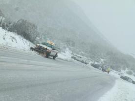
Travel may be hazardous on portions of I-8 as well as on mountain roads.
Areas where snow is expected include Boulevard, Campo, Cuyamaca, Descanso, Julian, Lake H enshaw, Morena Village, Mount Laguna, Oak Grove, Pine Hills, Pine Valley, Ranchita, Santa Ysabel and Warner springs.
Waterspouts are possible in coastal areas. Souhtwest to west winds are forecasts in mountains and deserts, with gusts up to 55 mph.
Travel in mountain areas will be extremely hazardous, the National Weather Service warns. If you must travel during the storm, carry food water, a flashlight, and blankets. Visibility will be poor due to blowing/drifting snow. In addition, watch for areas of black ice and slippery roads.


Recent comments