
Tsumani could reach Hawaii and Alaska this evening, San Diego shortly after midnight, with risk of more tidal waves due to powerful aftershocks.
East County Wildfire & Emergency Alerts
Note: An earlier tsunami watch has been upgraded to a tsunami advisory.
July 29, 2025 (San Diego) – The National Tsunami Warning Center has issued a tsunami advisory for the entire West Coast including San Diego County after , an 8.8 quake, struck Russia’s Kamchatka Peninsula late this afternoon. This is among the 10 strongest quakes ever recorded worldwide. The quake has been upgraded from earlier estimates.
Aftershocks including a 6.7 quake have also occurred.
The quakes and aftershocks have potential to produce tsunamis, or tidal waves, posing life-threatening danger.
Avoid low-lying coastal areas until the tsunami advisory is lifted. The earliest a tsunami could reach San Diego County is estimated at around 1:15 a.m. for La Jolla and Oceanside, slightly later in the South Bay and earlier for Northern California, Alaska and Canada.
The advisory extends indefinitely due to powerful aftershocks that produce additional risks.


 East County News Service


 East County News Service


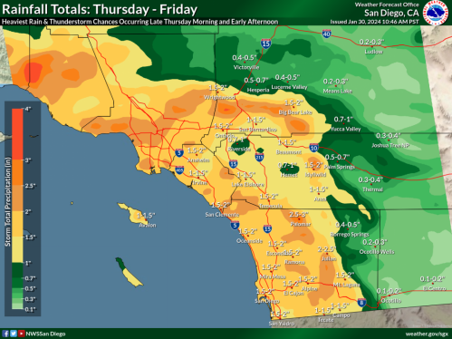
 January 8, 2025 (San Diego's East County) -- The National Weather Service has issued a red flag warning for San Diego County mountains and valleys today and tomorrow due to high winds and extreme fire danger. The strong winds that have fueled two large wildfires decimating Los Angeles County are forecast to move into San Diego County next.


 East County Wildfire & Emergency Alerts


 By Miriam Raftery

Recent comments