
Weather
Weather
 East County News Service
STORM BLANKETS EAST COUNTY MOUNTAIN AND HIGH DESERT COMMUNITIES IN SNOW; SOME ROADWAYS ARE CLOSED

SNOWSTORMS TO IMPACT I-8, CREATE WHITE-OUT CONDITIONS IN MOUNTAINS
 By Miriam Raftery
DROUGHT WORRIES RETURN AFTER DRIEST JANUARY AND FEBRUARY IN CALIFORNIA HISTORY
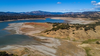 By Rachel Becker, CalMatters
HIGH WINDS ADVISORY ISSUED FOR THURSDAY

WILD WINDS IN ALPINE
 By Miriam
 WINDS, SNOW FLURRIES FORECAST

WINTER STORM WARNING: SNOWSTORM AND HIGH WINDS FORECAST MONDAY AND TUESDAY
 By Miriam Raftery
FLASH FLOODING THREAT TONIGHT AND FRIDAY; WHITE CHRISTMAS IN THE MOUNTAINS WITH SNOW THIS WEEKEND

WET AND WILD HOLIDAY WEATHER
 By Miriam Raftery
WARNINGS, WATCHES IN EFFECT ACROSS SOUTHERN CALIFORNIA AS STORM HITS REGION

MOUNTAIN EMPIRE ANNOUNCES REDUCED SCHOOL HOURS TUESDAY AND WEDNESDAY DUE TO STORM
 East County News Service
LET IT SNOW! STORM TO BLANKET MOUTAINS MONDAY THROUGH WEDNESDAY

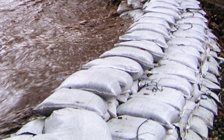
RAIN AROUND THE CORNER; GET FREE SAND BAGS FROM COUNTY, CAL FIRE
 By
By POWER OUTAGES BEGIN: THOUSANDS WITHOUT ELECTRICITY ON THANKSGIVING

RED FLAG WARNING: EXTREME FIRE RISK TONIGHT AND TOMORROW; SDG&E EXPANDS LIST OF POTENTIAL POWER OUTAGE AREAS

SANTA ANA WINDS BRING FIRE DANGER
 By Miriam Raftery
HEAT WAVE, FIRE RISK SUNDAY AND MONDAY
 East County News Service
ATMOSPHERIC RIVER TO SOAK REGION
 By Miriam Raftery
FROST, FREEZING TEMPERATURES TONIGHT IN MOUNTAINS AND DESERTS: SEVERE FIRE WEATHER FRIDAY
 By Miriam Raftery
HIGH WIND WARNINGS AND ADVISORIES TODAY

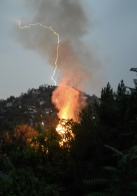
PHOTOS OF THE WEEK: LIGHTNING FIRE
 By Miriam Raftery
 FLEX ALERT CONTINUES TODAY AMID HEAT WAVE

EXCESSIVE HEAT WARNING TUESDAY THROUGH FRIDAY

FIRE WEATHER THIS WEEK
 By Miriam Raftery
THUNDERSTORMS THIS WEEK: HIGH FIRE DANGER AND POTENTIAL FLASH FLOODING
 By Miriam Raftery
SHOWERS AND POSSIBLE FLOODING TONIGHT, WARM WEATHER ON THE WAY
 East County News Service
FROM THE FIRE CHIEF’S CORNER: SHEDDING SOME LIGHT ON LIGHTNING
 By Fire Chief Sam DiGiovanna
THUNDERSTORM ROCKS DESCANSO AND ALPINE
 By Miriam Raftery


Recent comments