
Weather
THUNDERSTORM ROCKS DESCANSO AND ALPINE
 By Miriam Raftery
FLEX ALERT EXTENDED THROUGH SATURDAY: RESIDENTS ASKED TO CONSERVE POWER AND HELP PREVENT OUTAGES

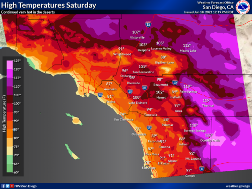
EXCESSIVE HEAT WARNING SATURDAY THROUGH MONDAY
 By Miriam Raftery, East County Magazine
MONSOONAL THUNDERSTORMS POSSIBLE TUESDAY THROUGH THURSDAY, ALONG WITH FLASH FLOODS, DAMAGING WINDS AND HIGH HEAT
 By Miriam Raftery
EXCESSIVE HEAT WARNING ISSUED TODAY AT 10 AM THROUGH MONDAY AT 9 PM
 Source: County of San Diego
HEATWAVE CONTINUES – ALONG WITH FIRE DANGER
 By Miriam Raftery
EXCESSIVE HEAT WARNING NEXT WEEK, HIGH FIRE DANGER: COUNTY TO OPEN COOL ZONES
 Update:
 EXCESSIVE HEAT WARNING FOR DESERTS

STRONG WINDS, HOT WEATHER AND A CHANCE OF RAIN FORECAST
 East County News Service
“DAMAGING” WINDS FORECAST FOR MONDAY AND TUESDAY, ALONG WITH SNOW AND FOG IN MOUNTAINS

RAIN BRINGS URBAN RUNOFF TO BEACHES: COUNTY HEALTH URGES PUBLIC TO STAY OUT OF THE WATER
 Source: County of San Diego
STORMS BRING HIGH WINDS, COLD TEMPERATURES AND SNOW AT LOW ELEVATIONS
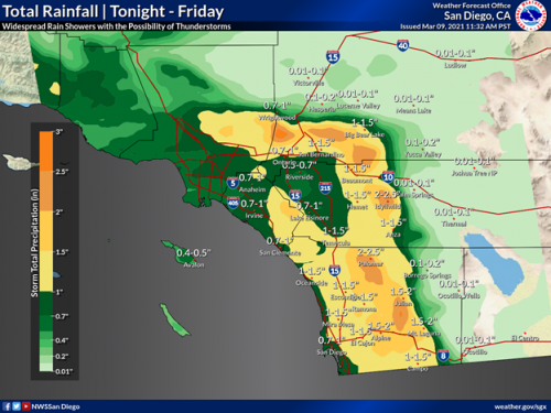
PHOTO OF THE WEEK: FLOCKING TO DESCANSO’S SNOW
 East County News Service
FLASH FLOOD WATCH: ATMOSPHERIC RIVER BRINGING HEAVY RAIN AND SNOW

PHOTO OF THE MONTH: COOL POOL
 East County News Service
CHP ISSUES "SNOW ETIQUETTE" GUIDELINES
 East County News Service
HEAVY SNOWFALL FORECAST FOR MOUNTAINS, POSSIBLE FLOODING IN URBAN AREAS

STRONG SANTA ANA WINDS TO ROAR INTO REGION

SNOW BLANKETS MOUNTAINS; WINTER STORM WARNING IN EFFECT THROUGH TUESDAY MORNING

KING TIDES, RIP CURRENTS AND WINDY WEATHER FORECAST FOR REGION
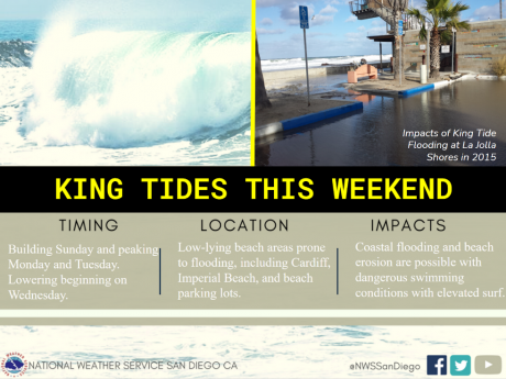 East County News Service
RED FLAG WARNING THURSDAY NIGHT THROUGH SATURDAY MORNING: HIGH FIRE DANGER

DRY WEATHER, FIRE DANGER RETURNS LATE THIS WEEK
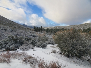
FIRST SNOWFALL OF SEASON BLANKETS MOUNTAIN AREAS, FREEZE FORECAST FOR HIGH DESERTS TONIGHT
FIRST COLD RAINS ON THE WAY, FREE SANDBAGS FOR UNINCORPORATED RESIDENTS
LIGHT RAIN POSSIBLE NEXT TWO DAYS, BUT HIGH WINDS AND FIRE DANGER BY TUESDAY

FIRE CONDITIONS REMAIN HIGH THROUGH THIS WEEKEND
 East County News Service
RED FLAG WARNNG: HIGH FIRE DANGER TODAY

SDG&E NOTIFIES APPROXIMATELY 700 BACKCOUNTRY RESIDENTS TO PREPARE FOR POTENTIAL PUBLIC SAFETY POWER SHUTOFFS DUE TO SANTA ANA WINDS AND FIRE WEATHER WATCH

EXTREME HEAT AND FIRE RISK FORECAST FOR LABOR DAY WEEKEND
 By Miriam Raftery


Recent comments