
Weather
Weather
 East County News Service
HIGH TEMPERATURE RECORDS BROKEN AS EXCESSIVE HEAT WAVE CONTINUES
 East County News Service
EXCESSIVE HEAT WARNING
 By Miriam Raftery
HIGH WINDS, RAIN SUNDAY NIGHT

NEW STORM TO BRING STRONG WINDS AND RAIN

HEAVY RAINS FORECAST FRIDAY THROUGH SUNDAY

WIND ADVISORY TUESDAY AFTERNOON AND WEDNESDAY MORNING

MORE RAIN AND SNOW COMING MID-WEEK

WINTER WEATHER ADVISORY: SNOW AT HIGH ELEVATIONS TODAY AND TOMORROW
 East County Wildfire & Emergency Alerts
COLD RECORDS BROKEN IN FEBRUARY

PHOTOS OF THE WEEK: DESERT GREENERY

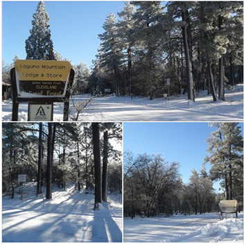
PHOTOS OF THE WEEK: DEEP SNOW

CHECK ROAD CONDITIONS BEFORE GOING TO THE SNOW
SNOW, ICE SHUTS DOWN I-8 AT ALPINE; SNOW BLANKETS MOUNTAIN AREAS

PHOTOS OF THE WEEK: SNOW IN DEERHORN VALLEY

LOW SNOW TONIGHT COULD DIP TO 1,500 FEET

PROPERTY OWNERS WITH RAIN DAMAGE ASKED TO COMPLETE SURVEY; RESULTS COULD DETERMINE REGION'S ELIGIBILITY FOR DISASTER FUNDS

NEW STORM COULD DROP SNOW DOWN TO 2000 FEET; FROST WARNING IN EFFECT FOR INLAND AREAS

HEAVY SNOW, ROAD CLOSURES IN MOUNTAINS


VALENTINE’S DAY STORM BREAKS RECORDS
OUTAGES AND ROAD CLOSURES
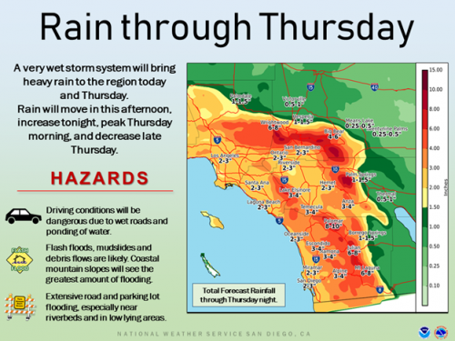
 A flash flood warning is in effect countywide through 1:15 p.m. Flash flooding, heavy rains and high winds .are causing power outages and road closures across our region including:
IT’S A GUSHER! NEW STORM TO DUMP UP TO 10 INCHES OF RAIN; FLASH FLOODING AND HIGH WINDS ARE LIKELY
MORE RAIN FORECAST

SNOW BLANKETS EAST COUNTY MOUNTAINS
WINTER STORM WARNING: SNOW DOWN TO 2500 FEET TONIGHT

STORM SOAKS REGION

PHOTO OF THE WEEK: STORM CLOUDS AT SUNSET

NEW STORMS TO BRING HEAVY RAIN, WINDS UP TO 80 MPH THIS WEEKEND

THUNDERBOLT JOLTS EAST COUNTY RESIDENTS

STORM SYSTEM SWOOPS INTO REGION BRINGING HEAVY RAIN, SNOW AND WAVES UP TO 14 FEET

Pages


Recent comments