
By Miriam Raftery
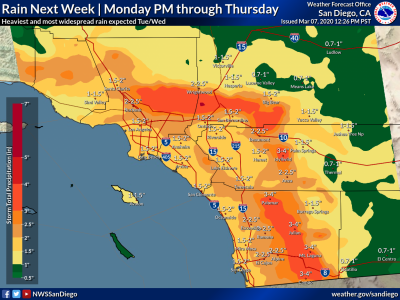
March 7, 2020 (San Diego) – Following light showers on Sunday, an “atmospheric river” is on track to drop heavy rainfall across our region Monday through Thursday including mountains, valleys, deserts and coastal regions of San Diego County. There is also a chance of thunderstorms and risk of flash flooding.
Heaviest rains are forecast for Tuesday and Wednesday, the National Weather Service predicts.
Snow levels could drop to 5,000 feet Sunday night, but are likely to rise to 6,500 feet by midweek.
From Monday to Thursday, the storm is forecast to dump three to four inches of precipitation on Mt. Laguna, Julian, Campo, and Palomar Mountain. Two to two and a half inches are forecast for Alpine, El Cajon, and Escondido, with up to two inches along the coast and as much as an inch and a half in Borrego Springs.


Comments
Hey, forget the rain, it's International Women's Day. . .