
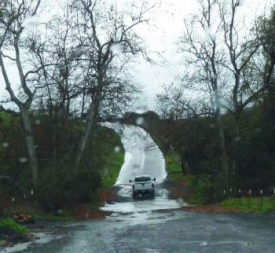
September 7, 2014 (San Diego's East County)--The National Weather Service has issued a flash flood watch for San Diego’s mountains and deserts this Sunday and Monday.
A surge of deep monsoonal moisture around tropical cyclone Norbert off the Baja coast will bring a high threat of showers and thunderstorms, particularly in the afternoons both days.
There is potential for three inches of rain and flash flooding, with greatest risk below desert slopes and recently burned areas.
Precautionary/preparedness actions: A flash flood watch means that conditions may develop that lead to flash flooding. Flash flooding is a very dangerous situation.
You should monitor later forecasts and be prepared to take action should a flash flood warnings be issued.
The National Weather Service has activated San Diego County Skywarn system.
Please report significant weather to the 800 number or click http://www.swskywarn.org/ReportWeather.php. Ham radio operators: use ECRA 147.030 or RACES Red.


Recent comments