
Photo by Kim Hamilton
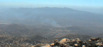
Update 5 p.m.: The fire has reached 100 acres and is burning uphill and into the Otay Truck Trail area, closer to homes. Smoke is visible from Highway 94.
Update from Cal-Fire at 4:40 p.m.: CAL FIRE is on scene of a 7 acre vegetation fire along the US/Mexico Border near Alta Road and Tin Can Hill (TB Map 1352 C3). Currently we have 17 engines, 6 fire crews, 4 airtankers, 2 helicopters, 1 bulldozer, 3 water tenders and 2 chief officers either on scene or enroute.
The fire was dispatched at 4:14 and the fire originated in Mexico. No structures are threatened.
May 22, 2013 (Otay) – Firefighters are battling a fast-spreading brush fire that started at Alta Road and Via De La Amistad in the east Otay area south of Otay Lakes. The fire has charred at least seven acres and has potential to burn 300, IPN reports.
There are currently no structure threats. On flank has slowed but the other side is “taking off” per IPN. Six hand crews and ten type-3 engines have been requested by the incident commander.
Sign up for free Viejas Wildifre & Emergency Alerts at the top right side of our homepage and also receive a free weekly copy of our newsletter. You can also follow ViejasAlerts on Twitter for brief text alerts on your mobile phone. We recommend all of the above since you don't know what form of communications will work best in a major regional emergency.


Recent comments