
 By Miriam Raftery
April 8, 2010 – How safe would giant wind turbines, power stations, high voltage lines, and a dump proposed for East County be during a powerful earthquake? Consumer advocates and area residents are raising those questions—and the answers in some cases are unsettling.
A storm of controversy over wind turbine seismic safety
 “I don’t think that the 400 to 500 foot tall wind turbines have ever undergone seismic testing,” Donna Tisdale, chair of the Boulevard Planning Group, told East County Magazine.” An Internet search conducted by ECM could turn up no evidence of seismic tests on large-scale wind turbines such as those installed at the Kumeyaay Wind Farm or the Tule Wind Farm project proposed for McCain Valley in an area frequented by hikers, campers, and horseback riders.
Questions are also being raised about plans by Sempra Energy, parent company of SDG&E, to bring power and fuel north from new proposed wind farms, solar facilities, and a natural gas pipeline in active seismic areas in Baja, Mexico. Photos reportedly taken in Rumorosa, Mexico, show major road buckling and damage near the site of one such proposed wind farm.
On February 7, 2010 the San Diego Union-Tribune reported that the University of California, San Diego (UCSD) planned to conduct a shake test of an 80-foot, 23,400 pound wind turbine at UCSD’s Englekirk Center, to be witnessed by wind industry representatives. However no results of that study have yet been published that our research could find. Moreover, turbines proposed in East County would be five to six times taller – as large as a 50 story building with blades as broad as a commercial jetliner’s wingspan.
In a February 15, 2010 letter to the California Public Utility Commission regarding the EIR/EIS scoping for the project, the Boulevard Planning Group called discovery that large wind turbines had not been studied for seismic stability “alarming.” The letter painted a chilling scenario. “Here, the turbines will be close to 500 feet tall which represents a potential for increased structural failure and the crashing down of multi-ton nacelles, blades, and hundreds of gallons of oil per turbine.”
When the 7.2 quake struck northeastern Baja Easter Sunday, Tisdale said “I actually went outside and was watching my house rattle and shake.”
Cumulative safety questions raised over proposed new power plants and energy facilities
 Powerful quakes have occurred in the past in the area where numerous major energy projects are planned, Tisdale noted. In February 1892, a quake of at least 7.2 magnitude (and possibly much stronger, by some accounts) caused ground fissures to open up in McCain Valley and Jewell Valley, also triggering rockslides in Mountain Springs, Carriso and Jewel Valley. “It actually caused some ground to liquefy,” Tisdale said of the century-old quake.
That quake resulted in a 20-foot displacement on the Laguna Salada fault in western Imperial County, the same fault that triggered Sunday’s massive quake in Mexico. The Imperial Valley substation is located just a few miles from that fault line, which is also near Stirling Energy’s proposed solar plant at Plaster City. In addition, the proposed Sunrise Powerlink would connect up to the Imperial Valley substation, then travel through additional seismically active areas in East County, which has felt as many as 100 aftershocks since yesterday’s quake. The Laguna Salada fault continues north of the border as the Elsinore fault, traveling through portions of East County.
“How will the Tule Wind, the Energia Sierra Juarez, and the Kumeyaay Wind I (existing) and Kumeyaay Wind II and III (proposed) turbines withstand another quake the size of the 1892 quake or larger?” the planning group’s letter asks. “What will be the result in the event of collapse of multiple turbines and related power lines, at the same time, and the release of hundreds to thousands of gallons of oil/fluid onto the ground surface and into the groundwater? What would be the potential for fire in a similar event and how would it be handled?”
How Safe is Sunrise Powerlink in a major earthquake?
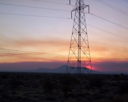 The Utility Consumers Action Network (UCAN) has also raised serious concerns about the seismic safety of the proposed Sunrise Powerlink project, noting in a recent UCAN blog post that “the Sunrise route begins at a spot that is the most seismically active in the U.S. with a high degree for a 7.0 or higher quake.”
Historically, high voltage towers have generally withstood earthquakes “pretty well,” UCAN executive director Michael Shames told East County Magazine. Quakes are more apt to cause damage to power substations and undergrounded power lines. But with portions of Powerlink slated to be undergrounded in Alpine and a new ECO-substation planned for construction in East County, that assurance is not entirely comforting.
But Laura Cyphert, co-founder of the East County Community Action Coalition, a group helping raise money to fight approval of Powerlink in court, cites wording in the final EIR (environmental impact review) for the Interstate 8 Alternative which would seem to suggest that towers could pose risks.
The EIR states that while towers would be designed to minimize damage from ground shaking, it acknowledges that “However, portions of the I-8 Alternative alignment would be subject to local strong groundshaking with vertical and horizontal ground accelerations that could exceed lateral wind loads, resulting in damage of collapse of project structures. Collapse of structures would potentially result in power outages, damage to nearby roads or structures, or death to people.” The EIR noted that mitigation measures to reduce effects of groundshaking should be required, but did not specify what those impacts would be.
“That sounds weak to me,” Cyphert concluded.
The EIR further noted that some areas of the route could be subject to “seismically induced ground failures, including liquefaction-related phenomena and slope failures along the I-8 Alternative,” as well as landslides. Further, it noted, the project “would expose people or structures to potential substantial adverse effects as a result of surface fault rupture at crossings of active faults…” and acknowledged that future quakes could occur anywhere along the various strands of the San Jacinto and Elsinore fault zones and other regional faults (including currently unknown faults)…”
The Elsinore fault runs north from the border, crossing I-8 near Pine Valley, then on to the Ramona/Julian area and Temecula. According to the Southern California Earthquake Center, the Elsinore fault has potential for a quake with a “probably magnitude” of 6.5 to 7.5.
SDG&E did not return ECM’s call requesting information on seismic safety standards for these projects. However, an SDG&E expert as testified that the Imperial Valley substation could withstand quakes in excess of 7.0 without damage.
UCAN has not analyzed the proposed ECO-substation. But the consumer watchdog group has assessed SDG&E’s proposed Sunrise Powerlink route—and pointed out that having both the existing Southwest Powerlink and Sunrise Powerlink “starting out at the same place in Imperial County directly next to one of the most active fault ( San Jacinto) areas in the U.S. was inappropriate,” Shames wrote in an e-mail today to ECM.
I n a brief submitted to the CPUC, UCAN contends that in its application to the CPUC, SDG&E failed to address the potential for seismic activity to compromise its Sunrise Powerlink project, which is located within 20 miles of the San Jacinto fault zone—the most seismically active branch of the San Andreas system at that time.
Moreover, the U.S. Geological Survey reported in April 2008 that there is a 99.7% chance of a magnitude 6.7 quake or larger striking California in the next 30 years—with odds of it occurring in Southern California 67%. Even more alarming, there is a 94% chance of a 7.0 quake or higher—and a 46% that the big one will measure more than 7.5 in magnitude. The report also cites strong potential for a future devastating quake to occur in the Imperial Valley, which has previously had two quakes over 7.0 and two others of 6.3 and 6.5 in the past century or so.
The Loma Prieta quake that devastating the Bay Area in 1989, by contrast, measured 6.9. It knocked three major power plants off line, one of them for several weeks, also damaging five substations—three severely.
As for testimony by a Mr. Riker of SDG&E, who has insisted the Imperial substation can withstand a 7.0 quake, UCAN countered in its brief that the statement was “unsupported by any documentary evidence, including the SDG&E report that he cited in his cross examination.” He said that report conflicted directly with USGS information, and that the San Jacinto fault zone is actually only six miles from the substation, significantly raising damage potential.
Moreover, the SDG&E report claimed major quakes occur only every 150 to 300 years. A 2008 USGS study found the San Andreas fault zone (which includes the Imperial area) was highly probably to experience a 7.0 seismic event within thirty years. UCAN concluded that “putting over half of SDG&E’s total import power capability at one seismically-risked substation creates unnecessary risk for SDG&E’s customers.”
That report reached a troubling conclusion for East County residents concerned about Powerlink being located in an area that has the highest seismic activity and one of the highest wildfire risks in California. “At a minimum, “ the USGS report warned state regulators at the CPUC, “the Commission can conclude that SDG&E has not presented an application that fully assesses seismic risk.”
Landfill seismic safety questions
Tisdale also raised concerns over the proposed Campo solid waste landfill, noting that fractured rocks and shifting in a major quake could cause damage to the liner system and leechate collection system.
Location of major projects , such as wind farms and the proposed dump, on tribal lands may further complicates efforts to assure that seismic safety requirements will be met, Tisdale suggested, since tribal lands are legally considered sovereign nations. But Robert Scheid, spokesperson for Viejas, provided documentation to show that a compact with the state signed by Viejas and other tribes provides that casinos and other structures on tribal lands open to the public must meet or exceed state building code requirements.
Tisdale voiced concerns that contamination from the landfill proposed on the Campo Indian reservation could enter the groundwater system and taint wells on private land. “In the supplemental draft EIS (environmental impact statement) there is actually a site-specific seismic impact waiver request.”
But Monique LaChappa, tribal chair of the Campo Indians, said that’s an inaccurate statement. “We care about making sure that it’s done in a professional, environmentally safe way.”
Rick Morck, project engineer for the proposed landfill, also confirmed the tribe aims to meet seismic safety standards of the federal government. “We have submitted to the U.S. Environmental Protection Agency a site-specific flexibility request. It means because the site for Campo Landfill is in what the EPA considers an active seismic area, we have to demonstrate that our design is safe from a seismic point of view.”


Recent comments