
 East County News Service
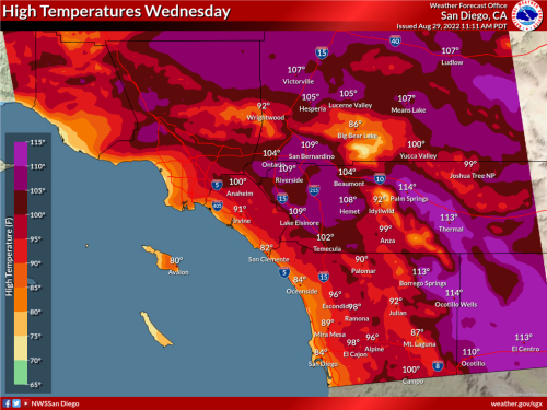
August 29, 2022 (San Diego’s East County) -- A long duration and high impact heat wave with triple-digit temperatures is expected to begin Tuesday and last through at least Labor Day weekend, the National Weather Service predicts.
Elevated fire weather conditions for inland valleys, mountains, and deserts are also forecast due to high heat and humidity dropping to 15-25%. “There is potential for large vertical plume growth with any new fires that develop, especially in the foothills and mountains,” the NWS warns.
Temperatures are forecast to soar to 110-116 degrees in low desert regions such as Borrego Springs, with high deserts reaching 105-110 degrees. San Diego County valleys are predicted to have temperatures from 95-105 degrees, with 88-95 degrees in our mountain areas.
The hot weather poses high risk for heat-related illnesses, especially for those with extended outdoor exposure, people who are heat sensitive, and/or without adequate cooling and hydration. Prolonged exposure to high heat can result in heat stroke and heat exhaustion.
Thunderstorms in mountain areas are also possible starting Thursday, though the chance of thundershowers is less than 20%.
For the latest forecast updates, visit weather.gov/sandiego.


Recent comments