
By Miriam Raftery
July 30, 2017 (San Diego) – San Diego County will experience monsoonal moisture starting Monday through at least Friday, with high heat, afternoon and evening thunderstorms and rain possible each day, especially over the mountains and deserts, though dangerous conditions are also forecast along the coast.
There is also a moderate flash flood potential in the mountains and deserts on Tuesday and Wednesday. Wind gusts of 50 miles per hour or more and hail of an inch or more in diameter are also possible.
Showers and lightning are possible along the coast Monday through early Wednesday, bringing strong rip currents and waves three to eight feet higher than normal, causing dangerous swimming conditions.
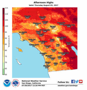
Hottest days will be Tuesday through Friday, with desert highs of 105 to 112 degrees, valleys 87 to 98 degrees, mountains below 5000 feet elevation 89-100 degrees, and beaches 73 to 81 degrees. Hottest day for the coast is expected to be Thursday, with Friday likely the hottest day for inland areas.


Recent comments