
ECM editor tackles “extreme hike” to one of our region’s most spectacular destinations
View a video of hikers sliding down the lower falls: http://www.youtube.com/watch?v=ZTi45vdpEFw

By Miriam Raftery
January 27, 2011 (San Diego’s East County) – Winter rains have swelled the waters cascading down Three Sisters Falls, creating a spectacular vista. No, this vision of paradise isn’t in Hawaii or the Sierra Nevada mountains. The trio of waterfalls is located on Boulder Creek in a remote area of San Diego’s East County.
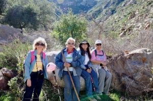
Long a secret of local hikers, the falls are accessible via a rigorous hike that includes scrambling down rocks and in one section,climbing down with a rope. On Sunday, I joined a group of 13 local hikers ranging in age from 18 to 72 to experience this adventure first-hand.
The trek was tougher than many of us anticipated—and well worth the effort as we savored the beauty of a place that has long been one of East County’s best-kept secrets, tucked within a remote canyon in the Cleveland National Forest.
 The center waterfall spills around 50 feet or more into a shimmering pool of jade green water. The more daring among our group wore swimsuits and slid down the lowest fall into a second pool below. The most intrepid made a risky ascent up towering rocks to the upper fall. Most of our group stopped at the base of the middle fall, basking in the sunlight while savoring the sound of a cascading curtain of water and the cooling mist blowing across our faces.
If you go, be sure your group includes experienced hikers and climbers. Bring a walking stick and ropes, lunch or snacks, a cell phone, first aid supplies, and plenty of water. Start out early in the day, as this is an all-day experience, and make sure to allow plenty of time to hike out and complete your drive back to Descanso before dark.

It took us about two hours to make the steep descent and two-and-a-half to hike out, though strong hikers can do it in less. You’ll want to allow lots of time to explore the area around the falls, however—and if you’re daring, even take a dip.
Stop off at the Cleveland National Forest station in Alpine or at the general store in Descanso to purchase a National Forest Adventure Pass, which should be displayed on your car. Warning! This trail is rigorous, so hike at your own risk and be prepared. (East County Magazine assumes no liability for injured readers!)
 We reached the trailhead by taking I-9 east to the Japatul Valley/Descanso exit north at Highway 79. In 1.3 miles, turn left on Riverside Drive and continue about 0.6 miles to Descanso. Behind the general store, turn onto Oak Grove Drive and follow it 1.6 miles to the intersection of Boulder Creek Road on the right. It takes about a half hour to travel the 13 or 14 miles down Boulder Creek Road; the first half is paved and the second half is a well-maintained, winding dirt road. You’ll find the trailhead in a hairpin turn that joins with Cedar Creek Road from the west. Park off the road, then set out on foot.
There is an alternate route to the trailhead through Julian, though the online descriptions I’ve read indicate the road can be slippery and is best traveled in a four-wheel drive vehicle.
The first section of the trail is a pleasant walk along a canyon rim, where you swiftly catch your first tantalizing glimpse of the falls far below. The initial section is in full sun, since mature trees in the area burned during the 2003 Cedar Fire. A brisk breeze was blowing when we started our hike, but soon calmed as we descended into the canyon. After a while, we reached a welcome section of shade, formed by a canopy of branches above the trail. Manzanitas, oaks, and wild sage are among the plants along the way.

Although the trail runs through the Cleveland National Forest, don’t’ expect a smooth stroll. “It is not an official Forest Service trail and thus is not maintained,” Steve Harvey with the U.S. Forest Service told East County Magazine. Wear sturdy hiking boots . My well-worn sneakers lacked adequate tread, and I slipped on loose rocks in a couple of steep sections along the trail.
This trail is best hiked on a sunny winter day, when temperatures are not too hot and you’re less apt to encounter rattlesnakes. We didn’t see any snakes, however a fisherman recently died from a snake bite along Boulder Creek, the waterway that feeds these falls, so keep your eyes on the trail and surrounding rocks.
 The trail soon became steep and in places, difficult due to loose rocks and gravel. In some areas, it was easiest to sit and scoot down from rock to rock.
Far down into the canyon, we came to a precipice of sheer rock that dropped perhaps 30 or 40 feet. The experienced hikers in our group secured rope to a large tree and assisted the more timid among us in making this descent. It was an empowering experience!
Our group included a local historian, photographers, writers, and a firefighter/paramedic (handy when a couple of us had scrapes or needed a wobbly ankle bound.) Lakeside Historian Betty McMillin informed us that Boulder Creek is fed by the Cuyamaca Reservoir (Lake Cuyamaca) before stepping down the Three Sisters Falls, then flows on to the El Capitan Reservoir in Lakeside.
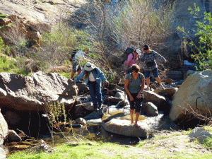
 Finally we reached the waters of Boulder Creek, an aptly named stream with massive rocks and clear, cool waters which we crossed several times. Be prepared to get your feet wet! Some opted to cross barefoot; mindful of that fisherman who stepped on a rattler, however, I decided to remove socks but cross with sneakers on, poking the waters ahead with my walking stick before stepping forward.
Everyone in our group reached the base of the first falls—quite an accomplishment given our wide differences in experience levels, ages, and general fitness. It’s one of the most rigorous hikes I've done, complete with scrambling over and around boulders, but the breath-taking view of the falls provided ample motivation to keep us all moving forward.
From the lower fall, it’s an easy walk up a sloping rock face to the base of the middle fall. There, most of us stopped to have lunch, while a few braved sliding down the lower fall for an East County extreme adventure. The rest of us were content to contemplate the awesome power of nature.
The hike out was far harder than the hike in, since it’s all uphill. Also, those areas where we slid down on our backsides proved impossible to walk back up due to so much loose debris, so we wound up using ropes for a couple of short sections to stabilize ourselves.

Dennis Richardson, ECM’s photographer who talked me into this adventure, passed out packets of an energy gel purchased at a hiking supply store. It tasted terrible, but proved invigorating.
I wanted to learn about the history of the falls. Was this a sacred site for ancient Native Americans? Did the Spanish or American armies pass through here, or did the early Friars find this place? Surprisingly, however, the people I spoke with at the Cleveland National Forest office and local historical societies had no information on the history of the falls--not even how they got their name. If you have any information on the history of Three Sisters Falls, please e-mail editor@eastcountymagazine.org.
One of the best parts of the hike was making new friends. Everyone in our group encouraged each other along the way. Out in the wilderness, troubles from elsewhere seemed to melt away and a sense of peace engulfed us as we walked.
After we returned to civilization, several of our hikers posted photos and even a video on Facebook. We talked about forming a hiking club to share more wonderful backcountry journeys in East County, and relished our memories from one of the most spectacular hiking experiences in Southern California.


Comments
Hikers
I was wearing the "Don't Mess With Texas" tshirt and my friend had on a blue shirt. We downloaded our satellite info and found out we went 4.3 miles in just under four hours with an elevation change of 990 feet. The World Trade Towers are 1368 feet, so think of climbing up and down one of those! (In loose dirt in places and lots of bouldering...) It is definitely an accomplishment.
Thanks for the comparison!
The Great Pyramid of Giza is 480 feet, so it's the equivalent of climbing the Pyramid TWICE.
I remember you - my Mom's from Texas and lots of my relatives are in the Lone Star State, too.
Three Sisters Hike
That was a wonderful hike! My friend and I passed you on the way back up. I agree that it was a strenuous hike and not for the inexperienced. Plus, I spent far too much time bouldering around by the falls wearing out the muscles I needed to climb back up. But I would do it again in a heartbeat!
Glad you had fun, too! Were
Glad you had fun, too! Were you the German family that we stopped and spoke with, or the group of hikers hunting for a misplaced friend? Or another bunch of folks perhaps.
I wish we'd had even more time to spend there, it was such a lovely place.