
By Miriam Raftery
Video by Rob Constantine
“Just like the Roman Empire, things that are built can decay, but they’re never lost as long as you keep them in your heart.” – Christian Woempner
May 7, 2009 (San Diego’s East County)—Traveling down Old Highway 80 with a man who helped build it proved a nostalgic and fascinating journey. “I love the sound of tires,” Craig Woemper, a 39-year veteran of Cal-Trans, said as the road ker-thumped beneath us. Raised in rural East County, Craig and his son, Christian, joined ECM’s editor and videographer for a trip down memory lane, providing insights not only into the road’s colorful history, but also sharing lore and legends of our region, assuring that these memories will not be consigned to the dust bin of history.
Once known as the “Broadway of America,” Highway 80 was the first coast-to-coast highway in the U.S. Locally it was built in stages, starting in 1917. In 1972, the roadway was officially decommissioned from Texas to California following completion of Interstate 8. Vestiges remain, including well-preserved sections in East County that have sparked interest among nostalgia buffs. Historic California 80 Corporation, a local group, seeks to preserve Old 80’s heritage: www.oldhighway80.com. But in the past year, a weak economy and high gas prices have caused a drop in visitors, turning many roadside communities into ghost towns almost overnight. If you want to see these milestones of a bygone era, you’d best visit soon—before they vanish into the dust of history as surely as the old stagecoach lines and wild west characters who once populated this region.
Traveling Back in Time: Our Journey Begins
We started our road trip on Main Street in El Cajon. Downtown El Cajon has a mix of historic storefronts and retro-style buildings. Farther east, past a string of old motels, we reach Lakeside, where a country store and an antique store lure visitors. Next we crossed to the south side of I-8, turning left at Lake Jennings Park and passing the Renegade Country Bar, since I-8 covered over a section of the original historic highway here.
“Old 80 had loops,” Craig recalled, pointing out places where they were lopped off to widen the road. We cruised through Flinn Springs, where a cherry-red caboose is all that remains of the once-powerful Southern Pacific Railroad station here. Another local highlight, Summer’s Past Herb Farms, offers delightful garden tours, herbs for sale, and herbal soap-making classes.
Turning right on Dunbar Lane to Alpine Blvd., we passed giant pipes beneath the roadway, big enough to drive a semi-truck through, built “in case something happens to El Capitan Dam,” Craig explained. The region is dotted with old barns, new homes, and goats grazing on a hillside.
Our videographer, Rob Constantine, observed, “Everyone in East County should have their own goat.” Craig recalled his childhood growing up in rural East County in the middle of the last century. “We had a horse named Bimbo. My Dad used to tie the horse to a tree and let him eat brush in a circle. We had her pull a sleigh in the snow at Live Oaks,” he said, recalling the town where he grew up. “All the kids would climb on. She’d bite,” he said, but added, “Even though she was mean, we still loved her.”
Mountain Towns and Byways
We rolled into Alpine, a quaint mountain town where it’s hard to tell what’s old and what’s new. The Alpine Inn, a steakhouse, offers “food and grog”; across the street, a statue of a bear tops Janet’s Montana Café, next door to the Vine Wines Bar & Bistro, a new venture in a rustic log building with a tree growing through the roof. Tucked behind, shops nestled in a village-type setting cluster along shaded walkways.
At the end of Alpine Boulevard, near the Frosty Acres fruit stand, we crossed back to the north side of I-8, where a sign reminds motorists that road improvements are made possible by Indian gaming revenues.
“This is original Old 80 right here,” Craig declared, as we pass by white horse fences and a creek before reaching the Viejas Casino and Viejas Outlet Center, both in a southwestern architectural motif. “This was a beautiful, pristine grazing valley,” he recalled, adding that a log trading post once occupied the site.
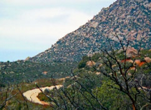
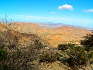
Further down the road, cracks in asphalt indicate concrete slabs breaking up beneath as we again venture south of 8. The landscape changes to boulder-strewn mountains , starkly beautiful. Craig pointed out a cut he helped slice through a mountain pass, then points to a cliff. “They were going to tunnel through that, but it was too expensive, so they said, `Just go through it.’” So they blasted and sliced a pass for the roadway.
Veering north onto a stretch of Highway 79, we turned left over the Los Terretinos Bridge built in 1917 and another left on Wildwood Glen. We traversed “part of Old 80 that people hardly ever go on,” Craig told us. Portions of the concrete road built in 1933, with original guard rail, can still be seen here. The vision conjured up memories for me as a child, driving cross-country from San Diego to Texas along this surprisingly narrow roadway. Now, burned trees stand as sentinels from a recent wildfire.
Rob, our videographer, attached a video camera onto his wheelchair using a custom-made clamp he designed. He rolled down a section of highway shooting footage, then turned the camera onto Craig. “We used to lay concrete in one piece, but it broke up. So we had to rely on slabs,” our highway worker-turned tour guide told us. “This is still in great shape, after all these years. Amazing.” Bending over, he hoisted a n old cornerstone that used to hold a post.
Backtracking to 79/80 we headed north toward Descanso, where Craig once worked out of a Cal-Trans yard based there (called California Department of Transportation in those days). “Once, my snow plough starting sliding on the ice,” he said, recalling his fear upon careening toward a car head-on. “Our eyes got real big, but I managed to put my plough and sander down in time.”
The next stretch of Old 80, called 79, took us through Guatay, a small town with businesses sporting colorful names like “The Hissing Camel” and “Yesteryear.” Next we drove down the Pine Valley grade across the historic Pine Valley bridge.
“I’ve seen bobcats and cougars up here,” Craig recalled. “In Mexico, they’d burn the fields. Wildlife was chased over; they’d run north and end up over here.” Now a border fence blocks access to migrants of all sorts, leaving the animals no place to run.
We reached Pine Valley, once a gold-mining town. On our return trip, we would later stop for lunch at Major’s Diner, a Pine Valley landmark bedecked in ‘50s décor including old highway signs, cut-outs of Betty Boop and James Dean, Marilyn Monroe memorabilia, old records, and a vintage car grill above an old-fashioned soda fountain bar.
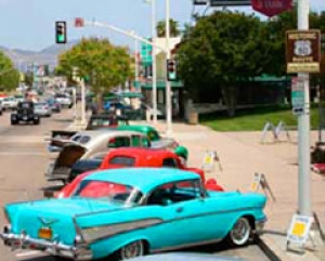
Opened in 1959 by John Sousa, Major’s is now owned by Debi McNamer. “We’re having our 50th anniversary party this summer,” she revealed. The July 11th blast-from-the-past bash will include a Fonzi look-alike contest, sock hop in the parking lot, vintage cars, 29-cent hamburgers and 10-cent coffee.
Across the street, Calvert’s Sports Bar (formerly the Pine Valley Inn), advertises an “Old Highway 80 band.” Craig grins. “I used to play my drums there, in that bar,” he recalled.
Past Pine Valley, we turned right on Sunrise Highway to the south side of the freeway. Red Manzanita trees rose up through patches of snow during our early spring trek. We passed a ranger station and border patrol checkpoint, rounding a curve where a collapsed mine has long since been boarded up.
History in the High Desert
At Buckman Springs, we stopped at the ruins of an old stone house that was once home to the town’s founder, Amos Buckman. “He bottled spring water and sold it as a health tonic,” said Craig. “People thought he was out of his mind.”
Then he disclosed a startling fact. “We found his grave marker and replanted it. We rerouted the right-of-way fence to go around his grave.” He pointed to the still-jagged fence line. “We actually bought a white marble headstone.” Across the street, relics of the old bottling plant also remain, marred by graffiti.
We passed fields of grazing cattle, a campground, and crossed over Cottonwood Creek near the La Posta Café and a new border patrol station. Next is a dangerous curve. “Lots of wrecks, it also iced up,” Craig noted.
The road weaves in and out of Cleveland National Forest, passing along wind farms on the Campo and Manzanita reservations, modern-day sources of power and revenue for tribal members.
Craig provided insight into how life has changed for local Native Americans in the past half-century. He recalled visiting the Manzanita reservation as a child in 1954. “A horse and wagon came down the road. All the houses were wiki-ups, they had draft animals and they lived without gas and electricity. It was like stepping back in time 100 years.”
Beyond, we traversed Victoria’s Grade and Crestwood Grade, scene of many wrecks. Looking to the right, we spotted a faintly rutted dirt road—remnants of an old stagecoach line. Soon after, Golden Acorn and La Posta casinos flank either side of the freeway.
Today, the Kumeyaay name is widely recognized throughout San Diego County, due in part to tribal gaming revenues and tribes giving back to the community with donations for firetrucks, healthcare and education. But it waasn’t always so. “I went to school with an Indian,” Craigreflected. “I asked what tribe. He said Kumeyaay. I thought he was pulling my leg; I’d never heard of it.”
Craig grew up in Live Oak Springs, where his parents ran the Live Oak Springs Resort—a campground with A-frame cabins , a restaurant and a dancehall. The resort still remains today, though under new ownership. His mother, former Postmaster for nearby Boulevard, still lives nearby. As a teen, he recalled, “We used to come out to the highway and put chains on cars.”
We reached the pinnacle of our journey at Tecate Divide, 3,890 feet high. “All the water from here on flows to Imperial County,” Craig noted.
In Boulevard , we discovered lost treasures of East County’ past. Beaver Creek Trading Company displayed pelts and vintage wagon wheels; next door the historic Quartz House dates to 1928. Salsa Lynda, a Mexican restaurant, seemed oddly out of place in a Swiss-style building. But Craig explained, “A lot of these houses used to belong to the Swiss. There were Swiss farmers in the Imperial Valley who came up here to summer houses to get out of the heat.”
We paused at Wisteria Candy Cottage, which has recently reopened, and savored chocolate/caramel turtles and honeycomb crunches. Other “dulces de la montana” included chocolate-dipped apricots and cherries, fudge nut balls, and more. We learned that one of Craig’s many jobs was working as a groundskeeper at the candy store.
Beyond, we reached grassy meadows strewn with wildflowers in McCain Valley. “Jim McCain, three brothers, they all homesteaded in McCain Valley. They were ranches in the 1800s,” Craig said. Today, members of the McCain family still ranch in the valley, which of late has made news over a controversial wind turbine project proposed for the scenic area. “I went to school with their kids. They all had cowboy names like Buckshot, Pie, Horsefly, Boots. Buckshot was an artist. Another, Boots, his widow married into the Hilton family,” Craig recalled.
His son, Christian, delighted in our journey onto the two-lane highway of yesteryear. “It’s the first time I’ve ever been on a road like this without going on the freeway,” he said. Christian shared his own warm memories of childhood in East county, including family camping trips at Cibbett’s Creek in Cleveland National Forest. “Dad used to take us up almost every holiday—Thanksgiving, Christmas,” he recalled.
At Bankhead Springs, we passed what’s left of an old pink building that was once home to silent movie star Tallujah Bankhead. The town was named for her father, a member of Congress and former Speaker of the House. More recently, the building served as a hotel, but today, the entire town has vanished, save for a few crumbling ruins of old homesteads. “I’d like to buy it,” Craig said of the former Bankhead home. “I’d like to live there.” His memories are not all fond, however. Passing a creek where families once picnicked, he recalled, “When I was a kid, someone got bit by a rattlesnake there and died.”
We dipped south toward the border, where high-voltage towers from the Southern Powerlink march across ridgelines. We also viewed the border fence and a colorful array of houses and shacks in Mexico beyond.
Entering Jacumba, named for a “jacum” or hot spring, we passed an organic farm and entered the high-desert town dotted, oddly, with palm trees. Craig recalled a job trimming palm trees, where he suffered cuts and encountered rats nesting in the fronds. “I told the lady when I bought my grave, no palm trees!” he exclaimed.
A stone chimney is all that remains of the once-famous Jacumba Hotel, a haven for Hollywood stars including Clark Gable and Mary Pickford, who came to enjoy the hot spring baths across the street. The bath house still stands, a ghostly reminder of a bygone era. A newer motel has a spa and pool with healing waters that smell faintly of sulphur. A cantina there welcomes visitors.
Once a thriving border town albeit with an illegal open border crossing, Jacumba is mostly dying on the vine. Boarded up buildings are everywhere. An antique store with old license plates in the window stood locked and dusty; it was unclear whether it had closed for good or just for the day.
“I used to go to elementary school here,” recalled Craig, who said “cheap land” attracted people to this desolate spot. Rumor has it that a tunnel once ran beneath Old 80 from a China camp to the spa.
East to the County Line
We entered a stretch of highway built in 1933 and head out to the desert, passing yuccas and towering boulder-strewn mountains. “This was a Cavalry trail and a stagecoach trail,” Craig noted as we pass in and out of Imperial and San Diego Counties, the road twisting and turning. “We put in a truck runaway ramp. It’s used quite a bit. Truckers th ink they’ve hit the bottom but haven’t, so they gear up and lose it.” Windswept and cold on a spring afternoon, the road here is flanked by wind screens to prevent vehicles from blowing off the road.
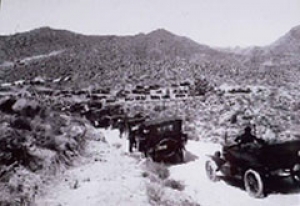
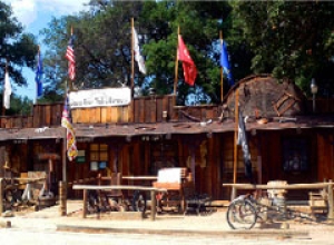
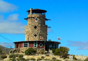
At In-Ko-Pah, we pulled off at one of East County’s funkiest landmarks---Desert View Tower and Boulder Park (thedeserttower@earthlink.net). Inside, we found an array of vintage postcards and posters for sale (including one of the old Jacumba Hotel, which proprieter Ben Schultz, gave me as a souvenir), as well as an eclectic collection including a stuffed boar’s head, bobcat, native handicrafts and gifts. Schultz proudly showed off a photo showing the highway back 1912, a narrow dirt road clogged with Model T Fords.
“There used to be an old bar. Guys all made a dollar a day and a jug of wine,” Schultz said of the highway workers who helped build the original roadway. “The tower was basically an ad for the bars.” During the Depression in 1933, an enterprising owner carved caves into the mountains and charged tourists to visit. “Everybody had to stop.” He recalled traveling Highway 80 when he was a kid. “There was a series of attractions—an old circus in Pine Valley, a rattlesnake show at Seely’s,” he said, shaking h is head nostalgically. “All gone.”
Today, he mused, “Nobody comes east now except crazy people.” But among those who venture forth, he observed, “You’d be surprised how many groups and people are interested in Old Highway 80 history.” We continued down a steep grade to the end of our journey, Mountain Springs, the last portion of Highway 80 located in San Diego County , though the road continues on in portions through Arizona, New Mexico and Texas before rejoining still-commissioned portions in the eastern U.S. We witnessed remnants of an old stage line near Mountain Springs, which was built around 1873, according to Craig. “Trucks literally would get blown over here,” he said, then shared a vivid—if terrifying—memory.
“I once flew in a plane from Yuma,” he recalled, pointing to a pass through the mountains at Mountain Springs. “We hit wind sheer and dropped 800 feet. I swear I saw rivets popping out of the wings. The plane was rocking.” After that, he admitted, “I gave up flying. I said, `I work on the highways. That’s dangerous enough.”
On the road back, Craig noted a few local sites missed earlier. At Rutland Springs, he pointed out a popular spot for hang-gliders to jump off a cliff and launch into mid-air. “With these thermal winds up here, they can stay up for hours,” he says. We passed through Descanso junction, where a trading post is still open to the public, before reluctantly turning back onto Highway 8 to complete our 130-mile-long day trip.
Reflections on the Past and Future
Pulling back into the fringes of civilization once more, Christian revealed his own dream to follow in his father’s footsteps. “I want to work for Cal-Trans to build better roads and become a civil engineer.”
Silent for most of our journey, Christian made a profound observation about the fading relics of history that he’d witnessed along Historic Highway 80 on this memorable day. “Just like the Roman Empire,” he mused, “things that are built can decay. But they’re never lost, as long as you keep them in your heart.”
View more photos by clicking the "slideshow" link at the top of this story. You can also view the video at the top left of this story.


Comments
Old 80
Great story. My dad and I went to the desert for years on rockhound trips. We would drive old highway 80 to Imperial County to a favoriite place.
https://en.wikipedia.org/wiki/Ogilby,_California
Stretch of Old Hwy 80 in Jacumba
I have been going clay pigeon shooting out in the mountains along the Old Hwy 80 for some time now. We always take the stretch of Old Hwy 80 at Boulevard just past The Golden Acorn Casino. Every time we go out I see something new as we pass by. I am really curious about a property that seems vacant the address on the mailbox is 43054, there are a bunch of statues all over this property. Two statues guard the entry way with Danger signs. What is the deal with the statues? Is it some sort of testing ground or some sort of scare tactic for any people trying to cross into USA land? You can see the border wall just after this property.
Statues on Old Highway 80
New video: Old Highway 80 Road trip!
Rob Constantine took a road trip with the Old Highway 80 association in October 2009--what fun!
http://www.youtube.com/watch?v=MXRRBQhn3m4