SOUTHERN FIRE, EAST OF JULIAN, FORCES EVACUATIONS

Printer-friendly versionPrinter-friendly version Share this


Update May 3, 2021 7 p.m. All evacuation orders, evacuation warnings, and road closures related to the Southern Fire have been lifted.

Update May 2, 2021 5:50 p.m.  The American Red Cross is providing hotel rooms for persons evacuated from the Southern Fire.  The hotel rooms are located in El Centro, CA.  If you are in need of a hotel room due to being evacuated, contact the American Red Cross at (571) 595-7910.

Update May 2, 2021 3:34 p.m.  The #SouthernFire has swelled to 5,184 acres per Cal Fire. Firefighters are making good progress and the blaze is now 25% contained.

Update May 2, 2021 2 p.m. p.m.  County Fire reports that  aircraft and Copter 129 are on scene; a helitanker and a second copter are en route. Tankers are unable to drop due to the wind. Fire is burning southwest of the Butterfield community. The County has issued a smoke advisory, noting that smoke is blowing southeast of the fire, into Anza-Borrego Desert State Park.

Update May 2, 2021 8:45 a..m.  The Southern Fire is apprxoimately 2900 acres and 0% contained, per Cal Fire San Diego Overnight, strong winds of 40-60 mph were observed; firefighers continue working to build a containment line. Animals evacuated can be sheltered at Vallecito County Park, 37349 Great Southern Overland Stage Route.  


East County Wildfire & Emergency Alerts

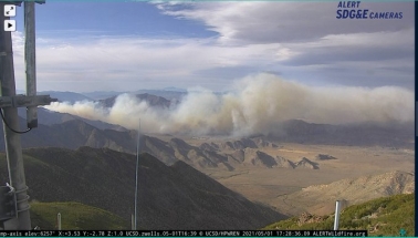
Photo via SDG&E webcam

May 1, 2021 (Shelter Valley) -- A fire near Agua Caliente State Park, the "Southern Fire" in the community of Mason Valley, has burned 1,200 acres in two hours late today. (Note, an earlier version of this article stated the fire was in the vicinity of Shelter Valley, based on incorrection information from the County Office of Emergency Services)

Cal Fire reports that three structures have been destroyed. Around 500 people have been evacuated from Butterfield Ranch Campground.

An evacuation center has been set up at Agua Caliente County Park at 39555 Great Southern Overland Stage Route, Julian, CA 92036.

So Cal Air Ops reports that tankers were dispatched but are unable to drop fire retardant due to strong winds.

Parts of Great Overland Stage Route (S-2) may be closed in both directions.  State Parks is manning a hard closure of S-2 at mile marker 30.
 
If you are asked to evacuate by fire or law enforcement, please do so immediately. Part of the fire was burning down a hill, misleadingly reducing the amount of smoke.

 
Be sure to understand and follow their directions of which evacuation route to take.
 
Butterfield Ranch residents were evacuated and told to drive south. Nearby residents should be prepared to evacuate, as SoCal Air Ops reports this will be an extended incident.
 
Photo, left by Richard Edwords
 
The San Diego Humane Society has been dispatched to assist with animal evacuations.
 
To receive free East County Wildfire & Emergency Alerts via email, sign up at the top right side of our homepage.  You can also follow EastCountyAlert on Twitter for brief text messages on your mobile phone. We thank the Grossmont Healthcare District for their sponsorship of our alerts.

Error message

Support community news in the public interest! As nonprofit news, we rely on donations from the public to fund our reporting -- not special interests. Please donate to sustain East County Magazine's local reporting and/or wildfire alerts at https://www.eastcountymedia.org/donate to help us keep people safe and informed across our region.

Comments

KPBS did correct their story, with weasel words

KPBS did eventually sort of correct their story, explaining that Mason Valley is in the "Shelter Valley Area", smh. It is a little bit like reporting that a fire is burning in Santee, but the fire is actually in Tierrasanta and they correct their article by saying the fire is in the "Santee area". I am left only with, geographic illiteracy is what it is in our country, I guess. What is funny is that in the KPBS article here they have an embedded map. It is clear to me. They could look at google earth or apple maps or even authoritative USGS maps for confirmation and context. I miss that kind of journalism, and it is also why I read and donate to ECM. In any case, Mason Valley and the Butterfield Community deserved better from the media. They deserved to be seen.

KPBS and News 7 do not correct

Kudos to East County Magazine for being the first to correct the misreporting on the location of the Southern Fire, which is burning in Mason Valley. I also contacted KPBS and NBC 7 San Diego yesterday May 7th, and neither has corrected yet. I am including my second message to KPBS here. We will see what their journalistic standards look like in the coming days.
"Call for retraction or further investigation of the facts
May 3rd, 2021. There is no fire in Shelter Valley and there has been no fire in Shelter Valley. We are concerned for our neighbors at Butterfield Ranch in Mason Valley. I have reported the facts to Joe Guerin via webform as of yesterday, and there is still no correction or seeming concern that this fire is impacting the Butterfield RV park community, and not the community of Shelter Valley. The latest update from 10:44(AM May 3rd) still states that the fire is burning in "Great Southern Overland, in the community of Shelter Valley."
Facts matter, and KPBS does have the reputation of being able to investigate and report on serious matters such as major fire incidents. Although I am not a professional journalist, it has been my sense that average journalists would normally strive to report which communities are effected, accurately, and further to understand why the mistaken reporting happened. And to correct. Professional journalists correct, it is nothing to be ashamed of.
I don't know this for certain, but signs are that CalFire may be correctly operating in terms of geographic coordinates, but that they have an impoverished sense of place names and the geography of our communities. This is probably something you would want to be aware of moving forward with reporting on fires, and it deserves reported out as to why CalFire is reporting to the media that there is fire in the Shelter Valley community, when there is not one.
If you want some help with the geography, I am happy to assist. Or if you want pictures or zoom of no smoke and no fire damage in Shelter Valley, please do ask. My concern is that focus on our "not burning" community is detracting from those actually suffering a disaster right now. The people of the Butterfield RV resort 10 miles from Shelter Valley deserve accuracy in your reporting.
Brett Stalbaum Shelter Valley"

Correction needed

The fire is not in the community currently listed as the location of the fire! Members of the community where the fire is not are having our social media blow up with concern for our well being. There are other long term consequences related to this factual error, insurance and the like. My better half was asked at church up in Julian today what the destruction in our community is. (Julian folks are often no more informed of the lower desert geography than people in San Diego are.) Again, there is no fire in SV. And I am not holding ecm too responsible for the mistake, there are on the order of hundreds of people living out here, and our geography is often misrepresented in the media. Maybe the confusion is that the fire station is here, or maybe even CalFire said the wrong words. But facts do matter and this should be corrected.

Thanks

I'm not terribly surprised that even firefighters are confused about our places. With just a number in the hundreds of people who live in and between SV and Canebreak, the geography of our remote backcountry is pretty obscure. Thanks for correcting them.