San Diego flood watch

STORM SERIES MOVING INTO AREA: FLOOD WATCH ISSUED

East County News Service

Last week’s storms brought 6-10 inches of snow to our mountains with up to 1.5 inches in urban portions of our county.  Now, multiple new storms are moving into the area, with rain now falling across the region and multiple atmospheric rivers soon to drench  our region, with the heaviest rains Thursday, the National Weather Service predicts.   A flood watch has been issued now through Thursday afternoon for San Diego’s inland and coastal areas, including cities such as La Mesa, Santee, Poway, and Escondido as well as San Diego.  Excessive runoff may result in flooding of rivers,  streams, and other low-lying and flood-prone locations.

Wednesday night through Thursday afternoon could bring rainfall rates of .5 to 0.75 inches per hour, with up to an inch per hour possible in lower mountain areas, along with thunderstorms.  Two to three inches of snow are forecast at higher elevations locally. A winter storm warning will remain in effect from Wednesday afternoon through Friday morning.


Error message

Support community news in the public interest! As nonprofit news, we rely on donations from the public to fund our reporting -- not special interests. Please donate to sustain East County Magazine's local reporting and/or wildfire alerts at https://www.eastcountymedia.org/donate to help us keep people safe and informed across our region.

FLOOD WATCH ISSUED SUNDAY THROUGH WEDNESDAY MORNING

East County Wildfire & Emergency Alerts

February 18, 2024 (San Diego) – The National Weather Service has issued a flood watch for  San Diego County’s mountains, valleys, and coasts,  as well as portions of Orange, Riverside,  San Bernadino ,Los Angeles and Oxnard counties. The watch is in effect tonight through Wednesday morning due to a Pacific storm moving into our region expected to bring up to 1.5 inches of rain locally.

A low pressure system from the north is forecast to bring widespread showers and isolated thunderstorms, with moderate to heavy rains capable of flooding in urban and low-lying areas.


Error message

Support community news in the public interest! As nonprofit news, we rely on donations from the public to fund our reporting -- not special interests. Please donate to sustain East County Magazine's local reporting and/or wildfire alerts at https://www.eastcountymedia.org/donate to help us keep people safe and informed across our region.

COLD STORM BRINGING WET WEATHER: FLOOD WATCH THURSDAY-FRIDAY

By Miriam Raftery

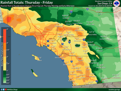
January 31, 2024 (San Diego)—On the heels of last week’s severe storm, another atmospheric river is moving into our region, bringing widespread rain, mountain snow as low as 3,500 feet, gusty winds, cold temperatures and possible thunderstorms.  A flood watch has been issued by the National Weather Service for Thursday morning through Friday morning for San Diego County’s mountains, deserts and valleys, with potential for flooding in some urban and low-lying areas as well as along rivers and streams.

The NWS has also issued a wind advisory for valley areas, a high surf and small craft advisory for coastal areas where waves could reach 10 feet.

Mountains and foothills have a 60% chance of 2-4 inches, a 10% chance of 4-6 inches, and a 5% chance of over 6 inches of precipitation.  Deserts could receive as much as 2 or more inches of rain, with .5 to 1 inch likely.  Valleys and coastal areas have a50%chance of 1-2 inches, a 40% chance of 2-3 inches,and a 5% chance of over 4 inches.


Error message

Support community news in the public interest! As nonprofit news, we rely on donations from the public to fund our reporting -- not special interests. Please donate to sustain East County Magazine's local reporting and/or wildfire alerts at https://www.eastcountymedia.org/donate to help us keep people safe and informed across our region.