 By Miriam Raftery
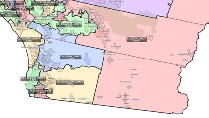
Map, left:: Proposed Congressional districts (View full size)
November 12, 2021 (San Diego’s East County) – Every 10 years, political districts at all levels undergo redrawing district boundaries to reflect demographic changes reported in Census data. A statewide commission this week released preliminary maps of Congressional, State Assembly and State Senate districts, which must be finalized by Dec. 7. In addition, a county commission meets Nov. 13 to consider draft maps for Supervisorial districts.
Some East County leaders have voiced concerned over certain proposed maps that if approved, could divide East County, lumping communities such as Lakeside in with coastal areas and some places in with communities in other counties. Opponents include the Lakeside Chamber Commerce, which supports alternative maps.
The stated intent, per the law, is to focus on trying to keep communities together based on factors including shared cultural, ethnic, geographic or economic concerns, voting rights and more. All districts must be approximately equal in populations, be contiguous with compact shapes to avoid gerrymandering and try to keep cities, towns and communities together.


Recent comments