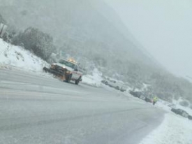
Weather

Weather

RED FLAG ALERT ISSUED FOR HIGH FIRE DANGER: HIGH WINDS AND FOG ALSO FORECAST

December 8, 2012 (San Diego’s East County) – The National Weather Service has issued a red flag warning  starting tonight at 6 p.m. through Tuesday at 2 p.m. for San Diego’s inland valleys.  A red flag alert means conditions for wildfire danger are high.

In addition, a high wind warning has been issued from now through 4 p.m. Monday by the National Weather Service in San Diego.  A dense fog advisory has also been issued for tonight and tomorrow morning.  Use caution if you must drive during these conditons.

Backcountry residents concerned about potential proactive electricicty shutdowns due to high winds can monitor SDG&E's website for updates at http://www.sdge.com/tools/windspeed-dashboard


Error message

Support community news in the public interest! As nonprofit news, we rely on donations from the public to fund our reporting -- not special interests. Please donate to sustain East County Magazine's local reporting and/or wildfire alerts at https://www.eastcountymedia.org/donate to help us keep people safe and informed across our region.

STORM TO BRING 10-FOOT WAVES TO SAN DIEGO

November 27, 2012 (San Diego)- A storm brewing over the northeast Pacific is expected to bring powerful swells and waves up to 10 feet high to San Diego’s coast this week, with the biggest breakers expected on Friday.  But dudes, don’t grab those surfboards and head west--according to the National Weather Service, “very strong rip currents will make for dangerous swimming conditions.” 


Error message

Support community news in the public interest! As nonprofit news, we rely on donations from the public to fund our reporting -- not special interests. Please donate to sustain East County Magazine's local reporting and/or wildfire alerts at https://www.eastcountymedia.org/donate to help us keep people safe and informed across our region.

FOG ADVISORY ISSUED

November 24, 2012 (San Diego's East County) -- The National Weather Service has issued an advisory warning of dense fog tonight in coastal and inland regions.  Fog is also forecast for tomorrow and Tuesday nights, clearing by Wednesday. 

Use caution on roadways and rely on low beams, not high beams in heavy fog. Flight delays are possible at Lindbergh Field.


Error message

Support community news in the public interest! As nonprofit news, we rely on donations from the public to fund our reporting -- not special interests. Please donate to sustain East County Magazine's local reporting and/or wildfire alerts at https://www.eastcountymedia.org/donate to help us keep people safe and informed across our region.

WINTER STORM AND HIGH WIND WARNINGS ISSUED

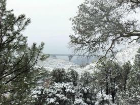
November 9, 2012 (San Diego’s East County) – Wind gusts up to 65 mph  and heavy snowfall in San Diego’s mountains are forecast for tonight through Saturday, with snow falling to the 4,000 foot level tonight in areas including Cuyamaca, Mount Laguna and Ranchita. Up to a foot of snow may fall on higher elevations, with 3 to 6 inches above 4,500 feet.

In valley and desert areas, rainfall and gusty winds are forecast as well by the National Weather Service in San Diego.


Error message

Support community news in the public interest! As nonprofit news, we rely on donations from the public to fund our reporting -- not special interests. Please donate to sustain East County Magazine's local reporting and/or wildfire alerts at https://www.eastcountymedia.org/donate to help us keep people safe and informed across our region.

RED FLAG WARNING: FIRE WEATHER WATCH

November 3, 2012 (San Diego’s East County) – The National Weather Service has issued a red flag warning for high fire risk in San Diego's mountains and a less severe fire watch in inland valley areas. The alerts start at 7 p.m. Sunday night through 4 p.m. Monday.  The red flag warning is issued due to low humidity and gusty winds forecast up to 30 mph. 

Temperatures should begin cooling later in the week, with partially cloudy weather and a chance of rain Thursday through Saturday.


Error message

Support community news in the public interest! As nonprofit news, we rely on donations from the public to fund our reporting -- not special interests. Please donate to sustain East County Magazine's local reporting and/or wildfire alerts at https://www.eastcountymedia.org/donate to help us keep people safe and informed across our region.

HURRICANE SANDY TO IMPACT “MILLIONS” ON EAST COAST; NEW YORK COULD HAVE 11-FOOT STORM SURGE

New York may be hardest hit; damage could extend inland as far as the Great Lakes

View live satellite video from NASA: http://www.nasa.gov/mission_pages/hurricanes/main/index.html

October 28, 2012 (San Diego) – San Diegans with relatives and friends in the eastern United States will want to keep  watch on the weather. One of the largest tropical cyclones ever in the Atlantic is expected to make landfall tonight and tomorrow along an 800-mile path of the East Coast.

“The system is so large that I would say millions of people are ...in areas that have some chance of experiencing either flash flooding or river flooding,” said Rick Knabb, director of the National Hurricane Center (NHC), CNN reports. The NHC warns that Hurricane Sandy is expected to bring “life-threatening storm surge flooding to the mid-Atlantic coast," though the risk extends hundreds of miles inland.


Error message

Support community news in the public interest! As nonprofit news, we rely on donations from the public to fund our reporting -- not special interests. Please donate to sustain East County Magazine's local reporting and/or wildfire alerts at https://www.eastcountymedia.org/donate to help us keep people safe and informed across our region.

RED FLAG WARNING ISSUED FOR "EXPLOSIVE" WILDFIRE POTENTIAL

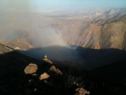
October 24, 2012 (San Diego’s East County) – The National Weather Service has issued a red flag warning, which means that critical fire weather conditions are occurring now or will shortly.A combination of strong Santa Ana winds, low relative humidity and warm temperatures will create explosive wildland fire growth potential.

Highest winds of up to 65 mph are forecast for late Thursday evening through early Saturday afternoon, with strong and gusty northeast to east winds.  Dry conditions will continue through the weekend, though with weakening winds.


Error message

Support community news in the public interest! As nonprofit news, we rely on donations from the public to fund our reporting -- not special interests. Please donate to sustain East County Magazine's local reporting and/or wildfire alerts at https://www.eastcountymedia.org/donate to help us keep people safe and informed across our region.

FOG, GUSTY WINDS FORECAST

October 21, 2012 (San Diego’s East County) – The National Weather Service has issued a hazardous weather statement for our region. Today and tonight, gusty southwest to west winds are forecast in mountains and deserts, with patchy dense fog on I-8 in mountain areas.  Monday through Saturday, strong gusty northeast to east winds are possible in East County’s mountain passes and canyons.


Error message

Support community news in the public interest! As nonprofit news, we rely on donations from the public to fund our reporting -- not special interests. Please donate to sustain East County Magazine's local reporting and/or wildfire alerts at https://www.eastcountymedia.org/donate to help us keep people safe and informed across our region.

FIRE WEATHER WARNING

October 18, 2012 (San Diego’s East County) – The National Weather service has issued a hazardous weather statement for our region. Elevated fire weather conditions are forecast for the next week due to hot, dry conditions in the mountains and gusty northeast to east winds in deserts and foothills. The most severe conditions are expected Thursday.

Yesterday, record high temperatures were set in El Cajon (102), Ramona (98) and Escondido (100).


Error message

Support community news in the public interest! As nonprofit news, we rely on donations from the public to fund our reporting -- not special interests. Please donate to sustain East County Magazine's local reporting and/or wildfire alerts at https://www.eastcountymedia.org/donate to help us keep people safe and informed across our region.

EXCESSIVE HEAT, ELEVATED FIRE WEATHER FORECAST

September 28, 2012 (San Diego)—Extremely hot temperatures and dry conditions are forecast for Sunday through Wednesday,creating elevated fire weather concerns.

Temperatures could reach 110 in the low deserts and 100 in high desert areas. In San Diego County valleys, 95 to 105 degree temperatures are forecast, with highs up to 95 in coastal and mountain areas.  


Error message

Support community news in the public interest! As nonprofit news, we rely on donations from the public to fund our reporting -- not special interests. Please donate to sustain East County Magazine's local reporting and/or wildfire alerts at https://www.eastcountymedia.org/donate to help us keep people safe and informed across our region.

RECORD TEMPERATURES , ELEVATED WILDFIRE RISK

September 15, 2012 (San Diego’s East County) – The Naitonal Weather Service warns of elevated wildfire risk over San Diego County’s mountains and valleys, with gusts of 25-35  mph forecast for today.  Yesterday,  high temperature records were broken in several local communities, including El Cajon, where the high reached 103 degrees.

Scorching hot temperatures and low humidity will continue today, with highs up to 107 forecast for coastal mesas and inland areas expected to peak at up to 103 degrees.  “Hottest locations will be near 108 degrees along I-15,” the National Weather Service predicts.


Error message

Support community news in the public interest! As nonprofit news, we rely on donations from the public to fund our reporting -- not special interests. Please donate to sustain East County Magazine's local reporting and/or wildfire alerts at https://www.eastcountymedia.org/donate to help us keep people safe and informed across our region.

FROM THE CHIEF'S CORNER: FLASH FLOOD SAFETY TIPS

By Fire Chief Sam DiGiovanna, East County Magazine’s “In-House Fire Chief”

September 5, 2012 (San Diego’s East County) – We continue in our summer “monsoon season” which can quickly and unexpectedly bring flash floods. More people lose their LIVES in floods than in any other weather-related event. 80% of flood deaths occur in vehicles, and most happen when drivers make a single, fatal mistake - trying to navigate through floodwaters.


Error message

Support community news in the public interest! As nonprofit news, we rely on donations from the public to fund our reporting -- not special interests. Please donate to sustain East County Magazine's local reporting and/or wildfire alerts at https://www.eastcountymedia.org/donate to help us keep people safe and informed across our region.

CALFIRE INFORMS ECM REGARDING MEXICO FIRE ALSO FLASH FLOOD ALERT ISSUED

September 4, 2012 (San Diego's East County) -- CalFire has informed East County Magazine that there is a fire  4 miles south of Otay Mountain. There is no danger to the U.S., but smoke is visible from the U.S. side of the border.

In addition, a flash flood warning has been issued for the eastern portions of the county. See http://www.wrh.noaa.gov/sgx/


Error message

Support community news in the public interest! As nonprofit news, we rely on donations from the public to fund our reporting -- not special interests. Please donate to sustain East County Magazine's local reporting and/or wildfire alerts at https://www.eastcountymedia.org/donate to help us keep people safe and informed across our region.

STORM, FLASH FLOODING POSSIBLE TODAY AND TOMORROW

September 5, 2012 (San Diego’s East County)--The National Weather Service has issued a hazardous weather outlook for San Diego County’s mountains, valleys and deserts.

There is a chance of afternoon and evening thunderstorms with heavy downpours, hail and gusty winds. Flash flood potential is low to moderate.


Error message

Support community news in the public interest! As nonprofit news, we rely on donations from the public to fund our reporting -- not special interests. Please donate to sustain East County Magazine's local reporting and/or wildfire alerts at https://www.eastcountymedia.org/donate to help us keep people safe and informed across our region.

FOR THE LATEST WEATHER UPDATES, ALSO CHECK THESE RESOURCES


Error message

Support community news in the public interest! As nonprofit news, we rely on donations from the public to fund our reporting -- not special interests. Please donate to sustain East County Magazine's local reporting and/or wildfire alerts at https://www.eastcountymedia.org/donate to help us keep people safe and informed across our region.

THE NATIONAL WEATHER SERVICE IN SAN DIEGO HAS ISSUED A FLASH FLOOD WARNING

August 22, 2012 (San Diego)--THE NATIONAL WEATHER SERVICE IN SAN DIEGO HAS ISSUED A FLASH FLOOD WARNING FOR EAST CENTRAL SAN DIEGO COUNTY IN SOUTHWEST CALIFORNIA UNTIL 630 PM. * AT 335 PM PDT...NATIONAL WEATHER SERVICE DOPPLER RADAR INDICATED PERSISTENT THUNDERSTORMS AND HEAVY SHOWERS OVER SHELTER VALLEY...AGUA CALIENTE SPRINGS...AND CANEBRAKE WHICH WILL LIKELY PRODUCE FLASH FLOODING. * LOCATIONS IN THE WARNING INCLUDE BUT ARE NOT LIMITED TO OCOTILLO WELLS...SAN FELIPE CREEK...VALLECITO WASH...FISH CREEK...HARPER CANYON WASH...AND HIGHWAY 78.


Error message

Support community news in the public interest! As nonprofit news, we rely on donations from the public to fund our reporting -- not special interests. Please donate to sustain East County Magazine's local reporting and/or wildfire alerts at https://www.eastcountymedia.org/donate to help us keep people safe and informed across our region.

SCATTERED SHOWERS AND THUNDERSTORMS THROUGH WEDNESDAY


Error message

Support community news in the public interest! As nonprofit news, we rely on donations from the public to fund our reporting -- not special interests. Please donate to sustain East County Magazine's local reporting and/or wildfire alerts at https://www.eastcountymedia.org/donate to help us keep people safe and informed across our region.

HAZARDOUS WEATHER FORECAST FOR MOUNTAINS AND DESERTS

August 21, 2012 (San Diego’s East County)—Scattered thunderstorms and heavy rains are forecast for Tuesday through Sunday in San Diego County’s mountains and desert areas.

Skywarn weather activation is requested for Tuesday.


Error message

Support community news in the public interest! As nonprofit news, we rely on donations from the public to fund our reporting -- not special interests. Please donate to sustain East County Magazine's local reporting and/or wildfire alerts at https://www.eastcountymedia.org/donate to help us keep people safe and informed across our region.

FLASH FLOOD WATCH IN OUR MOUNTAINS UNTIL 8PM

FLASH FLOOD WATCH IN EFFECT FOR THE MOUNTAINS AND DESERTS OF
SOUTHWEST CALIFORNIA FROM 10 AM THIS MORNING THROUGH 8 PM
THIS EVENING...

http://youronlineweather.com/coasts/

http://youronlineweather.com/valleys/

http://youronlineweather.com/mountains/

http://youronlineweather.com/deserts/


Error message

Support community news in the public interest! As nonprofit news, we rely on donations from the public to fund our reporting -- not special interests. Please donate to sustain East County Magazine's local reporting and/or wildfire alerts at https://www.eastcountymedia.org/donate to help us keep people safe and informed across our region.

SLOW COOLING THROUGH THURSDAY


Error message

Support community news in the public interest! As nonprofit news, we rely on donations from the public to fund our reporting -- not special interests. Please donate to sustain East County Magazine's local reporting and/or wildfire alerts at https://www.eastcountymedia.org/donate to help us keep people safe and informed across our region.

HARD TO BELIEVE IT'S SUPPOSED TO GET HOTTER


Error message

Support community news in the public interest! As nonprofit news, we rely on donations from the public to fund our reporting -- not special interests. Please donate to sustain East County Magazine's local reporting and/or wildfire alerts at https://www.eastcountymedia.org/donate to help us keep people safe and informed across our region.

FLASH FLOOD WARNING AND MORE SEVERE WEATHER ALERTS

August 13, 2012 (San Diego's East County) - The National Weather Service has isseud a flash flood warning for southeast San Diego County. Radar indicates flash flooding is occurring near the Live Oak Springs and Boulevard areas and other rural areas along the southern mountains.  A lesser flash flood watch is in effect for a broader area that includes San Diego County deserts and mountain.


Error message

Support community news in the public interest! As nonprofit news, we rely on donations from the public to fund our reporting -- not special interests. Please donate to sustain East County Magazine's local reporting and/or wildfire alerts at https://www.eastcountymedia.org/donate to help us keep people safe and informed across our region.

HOT INLAND FRIDAY WITH MINOR COOLING OVER THE WEEKEND


Error message

Support community news in the public interest! As nonprofit news, we rely on donations from the public to fund our reporting -- not special interests. Please donate to sustain East County Magazine's local reporting and/or wildfire alerts at https://www.eastcountymedia.org/donate to help us keep people safe and informed across our region.

SUNNY WEATHER TO SHINE FOR PADRES/CUBS CHARITY EVENT & PHIL'S BBQ


Error message

Support community news in the public interest! As nonprofit news, we rely on donations from the public to fund our reporting -- not special interests. Please donate to sustain East County Magazine's local reporting and/or wildfire alerts at https://www.eastcountymedia.org/donate to help us keep people safe and informed across our region.

Pages