
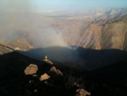
Update: Flooding is reported in Campo on Buckman Springs Road and in the Warner Springs area, where a fire crew was briefly stranded, the National Weather Service reports. Largest storms have developed over Borrego Springs, Ranchita, Shelter Valley and Warner Springs.
August 11, 2012 (San Diego's East County) - A flood advisory has been issued at 4:40 pm. for San Diego mountains and deserts. Affected areas include Borrego Springs, Julian, Pine Valley, Agua Caliente Springs, Banner, Boulevard, Canebrake, Cuyamaca Peak, Live Oak Springs, Mount Laguna, Oak Grove, Ocotillo Wells, Ranchita, Santa Ysabel, Shelter Valley, Tierra Del Sol and Warner Springs.


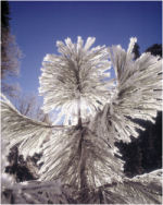 January 12, 2013 (San Diego’s East County) – The National Weather Service in San Diego has issued a warning of very cold nights with frost and freezing temperatures the next few mornings. Tonight through Tuesday, the warning includes areas west of the mountains as well as mountains, valleys and deserts. Temperatures may drop as low as 20 degrees in places.

 December 25, 2012 (San Diego’s East County) – A wind advisory has been issued by the National Weather Service for mountains and deserts in East County from 6 a.m. to 6 p.m. Wednesday, December 26. Gusts up to 50 mph may occur near ridge tops. Winds may make driving difficult, also producing blowing sand in desert areas.
  December 19, 2012 (San Diego’s East County) – The National Weather Service has issued a frost advisory in effect from 10 p.m. tonight, with frost likely again Thursday night. The warning includes San Diego County valleys, desert areas and wind-sheltered locations west of the mountains.
 By Miriam Raftery
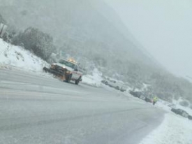
 November 9, 2012 (San Diego’s East County) – Wind gusts up to 65 mph and heavy snowfall in San Diego’s mountains are forecast for tonight through Saturday, with snow falling to the 4,000 foot level tonight in areas including Cuyamaca, Mount Laguna and Ranchita. Up to a foot of snow may fall on higher elevations, with 3 to 6 inches above 4,500 feet.
 September 28, 2012 (San Diego)—Extremely hot temperatures and dry conditions are forecast for Sunday through Wednesday,creating elevated fire weather concerns.
 September 15, 2012 (San Diego’s East County) – The Naitonal Weather Service warns of elevated wildfire risk over San Diego County’s mountains and valleys, with gusts of 25-35 mph forecast for today. Yesterday, high temperature records were broken in several local communities, including El Cajon, where the high reached 103 degrees.
 September 5, 2012 (San Diego’s East County)--The National Weather Service has issued a hazardous weather outlook for San Diego County’s mountains, valleys and deserts.
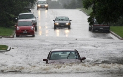
 August 21, 2012 (San Diego’s East County)—Scattered thunderstorms and heavy rains are forecast for Tuesday through Sunday in San Diego County’s mountains and desert areas.

Recent comments