 December 6, 2009 (San Diego) – The National Weather Service has issued a flash flood watch for recently burned areas of Southern California and lists the 2007 Poomacha burn area among the most vulnerable locations. Heavy rains of one inch per hour are forecast, capable of producing debris flows in and below burn areas from noon Monday until 8 p.m. Monday evening.
Other areas included in the flash flood watch are San Diego County mountains, as well as mountain and valley areas in San Bernadino and Riverside County, as well as Santa Ana Mountains and Foothills. Areas below lands burned in the Sheep, Oak Glen, Pendleton, Cottonwood and Poomacha Fires are listed as most vulnerable to flash flooding and debris flows.


 July 16, 2010 (San Diego’s East County) – A special weather statement has been issued by the National Weather Service for San Diego’s inland valleys, mountain and desert regions due to extremely high temperatures that today reached 112 in Borrego, 102 in La Mesa, and 101 in Ramona. More hot weather is forecast this weekend, with a chance of thunderstorms.
 April 22, 2010 (San Diego’s East County) – A surprise late-season storm didn’t stop firefighters county-wide from participating in a “Fill the Boot” campaign to collect donations for the Burn Institute—but did make for some chilly conditions.
 April 7,2010 (San Diego's East County) -- The National Weather Service has issued a high winds warning for mountain passes in East County. Santa Ana winds of 25-35 mph, with gusts up to 50 mph, are forecast for this afternoon. Motorists are advised to use caution, particularly high-profile vehicles, on I-8 east of Alpine as well as along easter portions of Highways 78 and 79.
  April 4, 2010 (San Diego) – The National Weather Service has issued a hazardous weather outlook and high wind warning for our region. A Pacific storm will bring wind, rain and snow to San Diego County starting late tonight. A high wind warning is also in effect through 10 p.m. Monday evening for mountain and desert regions in East County, with peak gusts in excess of 60 mph.
  March 6, 2010 (San Diego’s East County) – The National Weather Service has issued a winter weather advisory from 6 p.m. tonight through 2 p.m. tomorrow. Four to six inches of snow have been forecast above 4500 feet tonight in higher elevations including Palomar Mountain, Cuyamaca, Mount Laguna, and Ranchita.
 Update 3 p.m.: The tsunami effect locall remains in effect through 5:46 p.m. today for the entire west coast following an 8.8 quake in Chile. An early tidal surge proved minor in San Diego though Santa Monica had tides 2.2 feet above normal sea level. In other regions, second and third waves were higher than the first.
  January 25, 2010 (San Diego) – Just when you thought it was safe to go back in the water or drive on our mountain highways, the National Weather Service has issued a hazardous weather alert for all of southwestern California.
 January 21, 2010 (San Diego County) 5 p.m. -- High winds and heavy rain ravaged San Diego County today, prompting disruptions in transit service, flights, and closure of numerous roads, schools and businesses in East County and throughout our region.
 January 21, 2010 (San Diego’s East County) – The National Weather Service has issued an urgent alert for a winter storm warning in San Diego County mountains from 6 p.m. tonight through 6 p.m. Friday evening. Heavy snow measuring 8 to 16 inches is possible above 4,000 feet with greater amounts in some areas. Winds with gusts up to 45 mph, will cause near zero visibility in blowing and drifting snow.
 anuary 20, 2010 (San Diego County) 9:10 p.m. – Shortly after we issued an earlier alert about hazardous traffic conditions, CHP posted updates of several new hazards.
 January 20, 2010 (San Diego County, 7:45 p.m.) – Severe storms have left many roads flooded throughout the county, prompting road closures and rescue operations. CHP reports the following areas are flooded in East County:
 January 20, 2010 (San Diego County) –New storms today and tomorrow will bring thunderstorms with the potential to produce tornadoes , the National Weather Service advises. A flash flood watch is also in effect for San Diego County mountains, valleys and coastal areas.
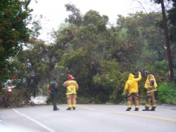 FLASH FLOOD WATCH ISSUED FOR LATE TODAY
 December 8, 2009 (San Diego) – Yesterday’s storm kept emergency service providers busy responding to vehicle accidents, downed power lines and electrical outages around the County.
 December 6, 2009 (San Diego’s East County) -- The National Weather Service has issued an urgent high wind watch for Monday and Monday night due to a strong winter storm. Strong gusty winds in mountains, valleys, coastal and desert areas will have potential to cause damage to trees and power lines.
 November 14, 2009 (San Diego’s East County) – The National Weather Service has issued a red flag alert for high fire danger area Sunday and Monday in San Diego County’s mountain areas, due to low humidity and gusty winds. In addition, a high wind warning has been issued for San Diego County mountains and valleys from Sunday morning through Monday afternoon.
  September 21, 2009 (San Diego) – The National Weather Service has issued a red flag warning cautioning Southern California residents of “explosive fire growth potential” due to a combination of strong winds and low humidity, which will be in effect from 9 a.m. Tuesday through 9 p.m. Thursday due to gusty winds and low humidity. The red flag warning includes inland, mountain and desert areas in San Diego's East County.
Recent comments