San Diego weather

MAJOR ROAD CLOSURES AND HAZARDS DUE TO SNOW, FLOODING, AND DEBRIS

January 7, 2016 (San Diego's East County) -- Snow, debris flows and flloding from heavy rainfall are making the morning commute tough. Here are the latest updates on closures and hazards impacting Highway 94, Interstate 8 and other highways as well as major surface streeets across East County.

  • Snow on I-8 just east of Kitchen Creek – snow ploughs are working (CHP)  Numerous accidents reported east of Pine Valley.
  • SR-94 closed both directions from Lyons Valley Rd. to Honey Springs due to flooding (Caltrans); CHP site indicates a “river” flowing 30-40 feet wide this a.m.
  • Sunrise Highway is open but you are required to carry chains. CHP is en route to check conditions on Highway 79 from I-8 to Julian.
  • Dehesa road from the school to willow glen has multiple mudslides and is a total mess.    Willow glen is completely closed by the quarry, a reader reports
  • State Route 94 at Buckman Springs Rd., vehicle overturned (CHP)
  • I-8 east west of Fuerte, off-ramp sign fell down and is in slow lane, per CHP
  • Ramona: B St. closed from 10th and at 11th due to flooding (DPW).  Also Magnolia dip is now closed at highway 78 and 500 feet north of Magnolia dip due to flooding in Ramona.
  • Spring Valley: Quarry Road from SR125 to Lakeview is closed due to flooding(DPW)


Error message

Support community news in the public interest! As nonprofit news, we rely on donations from the public to fund our reporting -- not special interests. Please donate to sustain East County Magazine's local reporting and/or wildfire alerts at https://www.eastcountymedia.org/donate to help us keep people safe and informed across our region.

SAN DIEGO RIVER EXPECTED TO REACH FLOOD STAGE TONIGHT


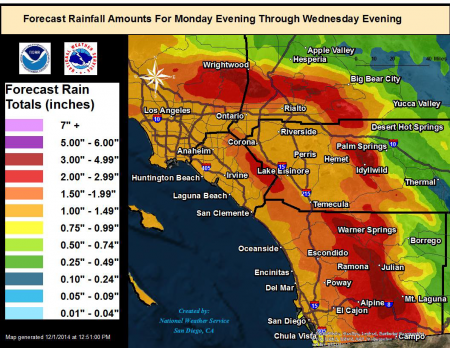
Flooding and boulders also block roadways in East County; snow impedes travel in mountains

By Miriam Raftery

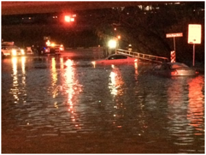
Photo: Ward Road in Mission Valley, courtesy of San Diego Lifeguards

January 6, 2016 (San Diego) – With yet another storm set to hit tonight, the San Diego River is expected to reach flood stage (11.5 feet) tonight, cresting in the pre-dawn hours.  The National Weather Service reports the river level has risen five feet in the past 24 hours to nearly 8 feet..  Major roads crossing the river in Mission Valley are closed and underwater including Fashion Valley Road, Avenida del Rio, Camino del Este, Camino de la Reina and Mission Center Road.  The San Diego Mission del Alcala church has flooded, as has the parking lot at Fashion Valley mall.

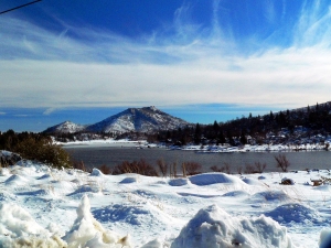
In East County, snow levels could dip down to 4,000 feet tonight, including the Julian area.  Chains are currently required on Mount Laguna/Sunrise Highway from State Route 79 to Highway 8.  There are also numerous closed or obstructed roadways:


Error message

Support community news in the public interest! As nonprofit news, we rely on donations from the public to fund our reporting -- not special interests. Please donate to sustain East County Magazine's local reporting and/or wildfire alerts at https://www.eastcountymedia.org/donate to help us keep people safe and informed across our region.

A WET START TO 2016: STORMS TO SWEEP IN, STARTING SUNDAY

East County News Service

January 1, 2016 (San Diego's East County)--“What could be better than the Rose Parade? How about a parade of storms!” The National Weather Service website in San Diego states on New Year’s morning. Starting late Sunday, the first in a series of storms will move in, bringing light rain across Southern California, with the heaviest rainfall forecast for southern San Diego County.  More storms will bring additional rain throughout the week, with heavy downpours  at times.  Snow is forecast for 4,500 feet elevation and higher.

Watch for blowing snow and dust in the mountain and desert areas.


Error message

Support community news in the public interest! As nonprofit news, we rely on donations from the public to fund our reporting -- not special interests. Please donate to sustain East County Magazine's local reporting and/or wildfire alerts at https://www.eastcountymedia.org/donate to help us keep people safe and informed across our region.

MORE SNOW MAY FALL ON MOUNT LAGUNA


East County News Service

Photo: Mt. Laguna on December 29, 2015, courtesy UCSD's HP WRen webcam

December 30, 2015 (Mt. Laguna)--Visitors flocked to Mount Laguna yesterday after a light snowfall left just enough for sledders to enjoy some winter fun.  A frost advisory is in effect for much of our region tonight through Thursday, with clear skies forecast for New Year’s Eve.

Though warmer weather this weekend is expected to melt away those patches of snow remaining, a new storm expected to hit Wednesday and Thursday of next week could bring more snow to the region, including Julian as well as Mt. Laguna—so keep those snow boots and sleds handy.


Error message

Support community news in the public interest! As nonprofit news, we rely on donations from the public to fund our reporting -- not special interests. Please donate to sustain East County Magazine's local reporting and/or wildfire alerts at https://www.eastcountymedia.org/donate to help us keep people safe and informed across our region.

SNOW, ICY ROADWAYS IN MOUNTAINS


East County News Service

File photo: Snow in Cuyamacas by Grace Schleiser

December 28, 2015 (San Diego’s East County) – A winter storm is bringing snow, ice and fog to our mountain regions.

Chains are required due to icy/snowy conditions on the Julian-Sunrise Highway from State Route 79 to Old Highway 80, according to the County Department of Public Works. Caltrans reports icy conditions on I-8 at Mountain Pass as well as on State Route 76 at Palomar Mountain.

The Laguna Mountain Lodge reports on its Facebook page that snow is falling on Mt.Laguna.  Residents across East County report snow in the Lake Cuyamaca area, an iced over pond in Descanso and cold conditions across our inland region.


Error message

Support community news in the public interest! As nonprofit news, we rely on donations from the public to fund our reporting -- not special interests. Please donate to sustain East County Magazine's local reporting and/or wildfire alerts at https://www.eastcountymedia.org/donate to help us keep people safe and informed across our region.

HIGH WINDS, RAIN AND SNOW TO AFFECT HOLIDAY TRAVEL


East County News Service

December 24, 2015 (San Diego’s East County) – The National Weather Service has issued a high wind warning in effect from Christmas Eve through Christmas morning in San Diego’s mountain and desert regions.  Winds of 35-40 miles per hour with gusts up to 80 mph are forecast. 

A cold front is also moving across the region, bringing rain and snow down as low as 3,000 feet.


Error message

Support community news in the public interest! As nonprofit news, we rely on donations from the public to fund our reporting -- not special interests. Please donate to sustain East County Magazine's local reporting and/or wildfire alerts at https://www.eastcountymedia.org/donate to help us keep people safe and informed across our region.

SNOWY, WINDY WEATHER TO SOCK REGION STARTING TONIGHT

By Miriam Raftery

December 10, 2015 (San Diego’s East County) – A low pressure trough moving south into our region is forecast to bring strong westerly winds, showers and mountain snow tonight through Friday, meteorologist Mark Moede with the National Weather Srevice in San Diego advises.

Wind gusts could reach 60 to 70 miles per hour, posing hazards to high profile vehicles in mountains and deserts, including on I-15, I-8, and I-10.  There is also a chance of thunderstorms, hail and brief, heavy downpours possible.


Error message

Support community news in the public interest! As nonprofit news, we rely on donations from the public to fund our reporting -- not special interests. Please donate to sustain East County Magazine's local reporting and/or wildfire alerts at https://www.eastcountymedia.org/donate to help us keep people safe and informed across our region.

WHITE THANKSGIVING IN EAST COUNTY


East County News Service

November 20, 2015 (San Diego’s East County) – The National Weather Service is forecasting snow Wednesday and Thursday down to 3,000 feet, potentially including I-8 in East County.  Significant levels of snow are forecast above 5,000 feet, bringing a white Thanksgiving to our mountain areas. 

Holiday travelers should use caution due to slippery roads and strong west winds, as well as potential for ice, snow, and of course, wild turkeys!


Error message

Support community news in the public interest! As nonprofit news, we rely on donations from the public to fund our reporting -- not special interests. Please donate to sustain East County Magazine's local reporting and/or wildfire alerts at https://www.eastcountymedia.org/donate to help us keep people safe and informed across our region.

STRONG WINDS, SHOWERS SUNDAY AND MONDAY


East County News Service

November 14, 2015 (San Diego’s East County) –Strong winds across our region are forecast for Sunday afternoon through Monday, with gusts over 70 miles per hour possible on mountain crests and desert mountain slopes and gusts of 35 to 60 mph in mountain and desert areas. 

Gale force wind gusts of 35 to 40 knots are also forecast over coastal waters, says Stephen Harrison, meteorologist with the National Weather Service.

Showers are also forecast, with rainfall light in most areas, though mountains could receive a half inch of precipitation.


Error message

Support community news in the public interest! As nonprofit news, we rely on donations from the public to fund our reporting -- not special interests. Please donate to sustain East County Magazine's local reporting and/or wildfire alerts at https://www.eastcountymedia.org/donate to help us keep people safe and informed across our region.

WIND ADVISORY


November 10, 2015 (San Diego’s East County) – A wind advisory has been issued for San Diego County’s mountains and deserts through 4 p.m. today.

West winds of 20 to 30 miles per hour are forecast with isolated gusts up to 55 miles per hour possible, particularly along mountain ridges and desert slopes.


Error message

Support community news in the public interest! As nonprofit news, we rely on donations from the public to fund our reporting -- not special interests. Please donate to sustain East County Magazine's local reporting and/or wildfire alerts at https://www.eastcountymedia.org/donate to help us keep people safe and informed across our region.

STORM WALLOPS REGION: TRAPS 20 CARS IN FLOODWATERS


By Miriam Raftery

November 4, 2015 (San Diego’s East County) –Last night’s storm brought lightning, thunder and heavy rains across Southern California, bringing welcome relief from drought but wreaking havoc on area highways.  All lanes flooded on State Route 94 near the College exit and vehicles exiting on Federal Blvd. quickly became stuck in rising floodwaters  reportedly up to the hoods – sending some cars afloat, necessitating rescues. ECM news partner 10 News has video shot by one motorist trapped in flooding: http://www.10news.com/news/video-san-diego-couple-trapped-in-floating-car .

The deluge last night fell on already rain-soaked areas from lighter showers earlier in the day. By 1 p.m., over an inch of rain had already fallen in Lemon Grove and many mountain areas, with 1.39 inches recorded at the Pine Hills area near Julian.


Error message

Support community news in the public interest! As nonprofit news, we rely on donations from the public to fund our reporting -- not special interests. Please donate to sustain East County Magazine's local reporting and/or wildfire alerts at https://www.eastcountymedia.org/donate to help us keep people safe and informed across our region.

HEAT ADVISORY ISSUED

East County Alerts

October 11, 2015 (San Diego)--The National Weather Service in San Diego has issued a heat advisory for San Diego County inland coastal and western valley areas from 11 a.m. to 6 p.m. Sunday (today).

Temperatures are expected to range from 90 to 95 degrees for inland coastal areas and 95 to 99 in western valley areas.

The County issued an alert at 10:45 a.m. today. The County continues to operate the Cool Zones program and has designated buildings as cooling centers.


Error message

Support community news in the public interest! As nonprofit news, we rely on donations from the public to fund our reporting -- not special interests. Please donate to sustain East County Magazine's local reporting and/or wildfire alerts at https://www.eastcountymedia.org/donate to help us keep people safe and informed across our region.

STORM BREAKS RECORDS


East County News Service

The National Weather Service reports that Tuesday’s storm, remnants of Hurricane Linda that drenched our region, has broken rainfall records.

Lindbergh Field got 1.21 inches of rain on Tuesday alone, breaking the previous record for September 14th set 109 years ago – and that old record was just over a tenth of an inch.Tuesday was also the second wettest day in September ever.


Error message

Support community news in the public interest! As nonprofit news, we rely on donations from the public to fund our reporting -- not special interests. Please donate to sustain East County Magazine's local reporting and/or wildfire alerts at https://www.eastcountymedia.org/donate to help us keep people safe and informed across our region.

FLASH FLOOD WATCH ISSUED AS HEAVY RAINS FROM HURRICANE LINDA HIT EAST COUNTY


Some dangerous road conditions are reported across region

East County News Service

Photo by Paul Cummings: View from Mt. Laguna looking south at 1:30 p.m.

September 8, 2015 (San Diego’s East County ) – The National Weather Service has issued a flash flood watch for San Diego County’s mountains, lower and upper deserts in effect now through Thursday.

Tropical moisture is building across the region, bringing thunderstorms , locally heavy rainfall and flash flooding possible.  Heavy rain and flooding are reported currently in Boulevard and Pine Valley, the CHP website reports.  A mudslide is reported on San Felipe Road 2 miles south of State Route 79, blocking the roadway.


Error message

Support community news in the public interest! As nonprofit news, we rely on donations from the public to fund our reporting -- not special interests. Please donate to sustain East County Magazine's local reporting and/or wildfire alerts at https://www.eastcountymedia.org/donate to help us keep people safe and informed across our region.

STORMS POSSIBLE MONDAY THROUGH WEDNESDAY


East County News Service

August 22, 2015 (San Diego’s East County) – Monsoonal flows could bring afternoon and evening thunderstorms, lightning and heavy downpours Monday through Thursday in East County, along with gusty winds.


Error message

Support community news in the public interest! As nonprofit news, we rely on donations from the public to fund our reporting -- not special interests. Please donate to sustain East County Magazine's local reporting and/or wildfire alerts at https://www.eastcountymedia.org/donate to help us keep people safe and informed across our region.

WET WINTER ON THE WAY


By Tasha Matthews

August, 17, 2015 (San Diego)—National Weather Service forecasters are predicting a wet winter in San Diego due to the probability of a strong El Niño, perhaps the strongest since records began in 1950.

An El Niño occurs as a result of warming ocean surface waters which release heat into the atmosphere over the Pacific, creating a chain reaction that can result in cloud formation, storms and heavy rainfall.


Error message

Support community news in the public interest! As nonprofit news, we rely on donations from the public to fund our reporting -- not special interests. Please donate to sustain East County Magazine's local reporting and/or wildfire alerts at https://www.eastcountymedia.org/donate to help us keep people safe and informed across our region.

EXCESSIVE HEAT WARNING ISSUED FOR WEEKEND


By Miriam Raftery

August 13, 2015 (San Diego’s East County) –The National Weather Service has issued an excessive heat warning for San Diego County deserts and a heat advisory for mountain and valley areas. 

The warning and advisory are in effect from Friday at 1 p.m. to Monday at 9 p.m. Temperatures are forecast to reach 116 in Borrego Springs, 105 in Campo, 104 in Ramona, 102 in Alpine and 100 in El Cajon, shattering prior records.


Error message

Support community news in the public interest! As nonprofit news, we rely on donations from the public to fund our reporting -- not special interests. Please donate to sustain East County Magazine's local reporting and/or wildfire alerts at https://www.eastcountymedia.org/donate to help us keep people safe and informed across our region.

ROADWAY HAZARDS REPORTED FROM STORM

Update: 10 News reports cars underwater in Ramona.

Update: Heartland Fire also reports flooding in La Mesa on Avocado between 70th St. and Guava.

The City of La Mesa has cancelled its Sundays at Six concert tonight due to flooding around Harry Griffen Park.

July 19, 2015 (San Diego’s East County) – The CHP incidents page reports numerous roadway hazards related to the stormy weather, including some rockin' and rollin' mud, rocks and flooding. Here are the latest details:

  • State Route 79 at Chihuahua Valley: Sig Alert issued, roadway shut down
  • I-8 east, old Sunrise Highway: large rocks down in lanes
  • Highway 79 at Horizon View Drive: Rock slides blocking lanes
  • State Route 78 at Wynola:  Mud and rockslide blocking one side of highway
  • Old Julian Highway just west of Camel Dairy: road blocked both ways by rocks
  • I-15 south connection to Highway 52: rider down in lane
  • Ramona View Dr. in El Cajon: roadway completely washed out

Error message

Support community news in the public interest! As nonprofit news, we rely on donations from the public to fund our reporting -- not special interests. Please donate to sustain East County Magazine's local reporting and/or wildfire alerts at https://www.eastcountymedia.org/donate to help us keep people safe and informed across our region.

RECORD RAINFALL DRENCHES COUNTY, BREAKS CENTURY-OLD RECORD


By Miriam Raftery

Photo by Robert Gehr (c) 2015

July 19, 2015 (San Diego) – Saturday’s deluge, remnants of a hurricane off the Baja coast, set a new record rainfall for the month of July in San Diego and many other local cities, Alex Tardy, Meteorologist Manager at the National Weather Service, San Diego reports.  At Lindbergh Field airport, 1.03 inches of rain has fallen so far this month, topping the old record of 0.92 inches set back in July 1902.

Anza-Borrego Desert State Park got 1.16 inches and Ramona’s airport got a full inch. Campo received .99, while Alpine and El Cajon measured .95 inches on Saturday, putting all of these communities above normal for the whole month of July.

The downpour forced cancellation of some events, such as Concert at the Lakes in Santee.


Error message

Support community news in the public interest! As nonprofit news, we rely on donations from the public to fund our reporting -- not special interests. Please donate to sustain East County Magazine's local reporting and/or wildfire alerts at https://www.eastcountymedia.org/donate to help us keep people safe and informed across our region.

FLASH FLOOD WATCH: MOUNTAINS AND DESERTS


East County News Service

July 18, 2015 (San Diego’s East County) – The National Weather Service has issued a flash flood watch for the mountains and deserts through Sunday evening. Heavy rain is now falling across much of East County, with thunder and lightning reporting in La Mesa, El Cajon, mountain areas and other locations.

Moisture from Hurricane Dolores will continue to spread northward into Southern California today and Sunday, bringing thunderstorms and locally  heavy rainfall.


Error message

Support community news in the public interest! As nonprofit news, we rely on donations from the public to fund our reporting -- not special interests. Please donate to sustain East County Magazine's local reporting and/or wildfire alerts at https://www.eastcountymedia.org/donate to help us keep people safe and informed across our region.

FLOODING, FIRES, POWER OUTAGES AS STORM SWEEPS ACROSS EAST COUNTY


East County News Service

Photo: View from Lyons Peak, Jamul, courtesy UCSD HP Wren webcam

Update 3:30 p.m. -

  • Mudslide across roadway: Highland Valley and Archie Moore roads, Ramona, CHP site reports
  • Hellhole Canyon Preserve: Vegetation fire, North County, per scanner
  • Lightning fire on hillside, Bancroft and Campo Rd. reported, scanner and CHP

June 30, 2015 (Lakeside) 2:40 p.m. - Thunder, lightning and heavy fires are sparking multiple emergency responses across East County. Here are highlights within the past hour:

  • Flooding is reporting in Alpine at Tavern and East Willow Road exits.
  • A fire was reported at 94 near Shockey Truck Trail.
  • Fire crews have also been dispatched to Kitchen Creek near Cameron Truck Trail, per scanner traffic.
  • An earlier fire on Highway 67 near Slaughterhouse Canyon is out, halted at about 3 acres.
  • Power lines are down and a power pole reported leaning across the roadway at Dye Road in Ramona.
  • SDG&E reports power outages in Eastlake/Otay are impacting 171 customers with restoration estimated at 6:30 p.m.
  • A larger outage is affected 623 households in Dulzura, Potrero, Campo, Japatul Valley, Buckman Springs, And Morena Village areas with rsetoration estimated for 4:30 p.m.

Error message

Support community news in the public interest! As nonprofit news, we rely on donations from the public to fund our reporting -- not special interests. Please donate to sustain East County Magazine's local reporting and/or wildfire alerts at https://www.eastcountymedia.org/donate to help us keep people safe and informed across our region.

HEAT ADVISORY ISSUED FOR EAST COUNTY


County News Service; photo via PhotoSpin

June 16, 2015 (San Diego’s East County)--With prolonged high temperatures expected to reach up to 115 in San Diego County deserts over the next few days, County health officials are reminding the public to take precautions to avoid heat stroke and other heat-related illnesses.

The National Weather Service in San Diego has issued a heat advisory in effect now through Sunday at 7 p.m. for the lower desert areas of eastern San Diego County. Temperatures inland will be anywhere from 5 to 10 degrees above average with high temperatures forecast of 112 to 115 degrees. Nighttime temperatures will only drop into the 80s. Mountain and foothill areas in the county are expected to be warm as well with highs in the 90s. Coastal areas will be near-normal temperatures.

The County operates the Cool Zones program and has designated more than 115 air-conditioned buildings as cooling centers. Locations and hours of operation can be found on a new interactive map on CoolZones.org or by calling 2-1-1 San Diego. The sites are identified by a light blue Polar Bear Cool Zone logo.


Error message

Support community news in the public interest! As nonprofit news, we rely on donations from the public to fund our reporting -- not special interests. Please donate to sustain East County Magazine's local reporting and/or wildfire alerts at https://www.eastcountymedia.org/donate to help us keep people safe and informed across our region.

WINDS AND WINTER WEATHER FORECAST


East County News Service

February 27, 2015 (San Diego’s East County) – A winter storm is due to hit our region tonight through Monday, bringing strong gusty winds to mountains and deserts.  Possible thunderstorms are possible starting Sunday night, bringing rain and potentially heavy snowfall down to levels that may include Julian, Descanso and Pine Valley.

The Sheriff offered this reminder to motorists traveling in the mountains: Have a full tank of gas, water and food supplies in case you are stranded in traffic for several hours. Have snow chains for areas where they will be required. Public restroom facilities are limited...Be mindful of areas that are private property which are marked by signs and fences. Private property is off limits to the public for recreational snow activities.
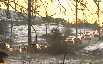
Parking violations will be enforced and citations will be issued. Vehicles blocking roadways and private property will be towed. Be aware of increased law enforcement activity to handle the large crowds.


Error message

Support community news in the public interest! As nonprofit news, we rely on donations from the public to fund our reporting -- not special interests. Please donate to sustain East County Magazine's local reporting and/or wildfire alerts at https://www.eastcountymedia.org/donate to help us keep people safe and informed across our region.

SNOW JAM!


By Miriam Raftery

Photo: courtesy 10 News

January 2, 2015 (Julian)--This week’s snowstorm transformed much of East County into a winter wonderland.

Nine inches of snow fell in Julian and a full foot blanketed the top of Mount Laguna, with several inches all the way down to Descanso, KNSJ’s home town.

The road to Julian has been ploughed and cleared for travel – but over this holiday weekend, that’s led to traffic jams as snow-loving San Diegans headed to the mountains.


Error message

Support community news in the public interest! As nonprofit news, we rely on donations from the public to fund our reporting -- not special interests. Please donate to sustain East County Magazine's local reporting and/or wildfire alerts at https://www.eastcountymedia.org/donate to help us keep people safe and informed across our region.

WINTER WONDERLAND


By Miriam Raftery

December 31, 2014 (San Diego’s East County) – A thick blanket of snow has fallen across much of  San Diego’s inland region, transforming the terrain into a winter wonderland this New Year’s Eve. Lindy Klengler sent photos taken at her Hidden Meadows home in Escondido at just 1700 feet elevation, showing snow around her swimming pool and atop palm trees. “Been here 22 years and never had this happen,” she says.

Melody Munoz and Donna Tisdale sent photos from Boulevard, where three to four inches of snow fell overnight and the temperature on New Year’s morning is a chilly 21 degrees. Snow has also blanketed Descanso and coated landmarks in Jacumba.

Julian received 9 inches of snow and on Mt. Palomar, 12 inches—a foot—has fallen, according to the National Weather Service.  ECM  news partner 10 News observes that level “beats Big Bear!”


Error message

Support community news in the public interest! As nonprofit news, we rely on donations from the public to fund our reporting -- not special interests. Please donate to sustain East County Magazine's local reporting and/or wildfire alerts at https://www.eastcountymedia.org/donate to help us keep people safe and informed across our region.

SNOW AT 1,000 FEET POSSIBLE; UP TO A FOOT OF SNOW FORECAST AT HIGHER ELEVATIONS


East County News Service

December 29, 2014 (San Diego’s East County)--The National Weather Service has issued a winter storm warning from 4 p.m. Tuesday night until 4 p.m. Wednesday for areas above 2,000 feet in elevation – though a dusting of snow could dip down to just 1,000 feet in some areas.

The storm, originating in Canada with very cold temperatures, could dump up to a foot of snow at elevations over 3,000 feet and 1 to 5 inches between 2,000 and 3,000 feet. Two to seven inches are forecast in high desert regions.


Error message

Support community news in the public interest! As nonprofit news, we rely on donations from the public to fund our reporting -- not special interests. Please donate to sustain East County Magazine's local reporting and/or wildfire alerts at https://www.eastcountymedia.org/donate to help us keep people safe and informed across our region.

FROST ADVISORY


December 26, 2014 (San Diego)—The National Weather Service is forecasting frost for the next two nights, through early Sunday morning. Saturday is expected to be the coldest nights.

There will be areas of frost and freezing temperatures in San Diego County’s valleys and deserts. In addition, frost is also forecast for the north coast, particularly Oceanside.


Error message

Support community news in the public interest! As nonprofit news, we rely on donations from the public to fund our reporting -- not special interests. Please donate to sustain East County Magazine's local reporting and/or wildfire alerts at https://www.eastcountymedia.org/donate to help us keep people safe and informed across our region.

SNOW FORECAST FOR MOUNTAIN PEAKS, RAIN TO SOAK REGION


By Miriam Raftery

December 15, 2014 (San Diego’s East County)--A dip in the jet stream along the West Coast is bringing more wet weather starting Monday night through early Thursday this week. The heaviest rain will be Tuesday morning and again Wednesday morning, with thunderstorms possible on Wednesday, the National Weather Service predicts.

Snow is forecast to fall in the mountains, with snow levels falling as low as 4500 feet by Wednesday.  A total of 6-12 inches could pile up above 5500 feet by Wednesday night, which includes Mount Laguna here in East County.


Error message

Support community news in the public interest! As nonprofit news, we rely on donations from the public to fund our reporting -- not special interests. Please donate to sustain East County Magazine's local reporting and/or wildfire alerts at https://www.eastcountymedia.org/donate to help us keep people safe and informed across our region.

RAIN! STORM COULD BRING FLOODING, WAVES 14 FT. HIGH


By Miriam Raftery

December 11, 2014 (San Diego) – A powerful storm is set to drench our region, bringing torrential downpours of up to a half inch of rain per hour. A flash flood watch has been issued through late Friday night, with highest risk in areas burned by recent wildfires including the Cocos Fire.  Dangerous surf conditions will occur along the coast. Strong rip currents are forecast, with waves of 7 to 14 feet Friday and Saturday.


Error message

Support community news in the public interest! As nonprofit news, we rely on donations from the public to fund our reporting -- not special interests. Please donate to sustain East County Magazine's local reporting and/or wildfire alerts at https://www.eastcountymedia.org/donate to help us keep people safe and informed across our region.

FLASH FLOOD WATCH ISSUED COUNTYWIDE


December 1, 2014 (San Diego) – The National Weather Service has issued a flash flood watch for Tuesday and early Wednesday in San Diego County’s mountain, valley and coastal areas.

Mountains and recent burn areas will have the greatest threat pontetial with up to five inches of rain forecast; be prepared for flooding and debris flows. Moderate to heavy rain in coastal and valley areas will produce urban flooding in flood-prone low-lying areas and streets with poor drainage.


Error message

Support community news in the public interest! As nonprofit news, we rely on donations from the public to fund our reporting -- not special interests. Please donate to sustain East County Magazine's local reporting and/or wildfire alerts at https://www.eastcountymedia.org/donate to help us keep people safe and informed across our region.

Pages